You are here: Home > Network List > TA - USArray Transportable Network (new EarthScope stations) Stations List
> Station R25A Fountain Ranch, Boone, CO, USA > Earthquake Result Viewer
R25A Fountain Ranch, Boone, CO, USA - Earthquake Result Viewer
| Earthquake location: |
Near S. Coast Of Honshu, Japan |
| Earthquake latitude/longitude: |
33.2/137.9 |
| Earthquake time(UTC): |
2009/08/09 (221) 10:55:55 GMT |
| Earthquake Depth: |
297 km |
| Earthquake Magnitude: |
6.5 MB, 7.1 MW, 7.1 MW |
| Earthquake Catalog/Contributor: |
WHDF/NEIC |
|
| Network: |
TA USArray Transportable Network (new EarthScope stations) |
| Station: |
R25A Fountain Ranch, Boone, CO, USA |
| Lat/Lon: |
38.15 N/104.28 W |
| Elevation: |
1461 m |
|
| Distance: |
88.5 deg |
| Az: |
44.254 deg |
| Baz: |
312.065 deg |
| Ray Param: |
0.04184646 |
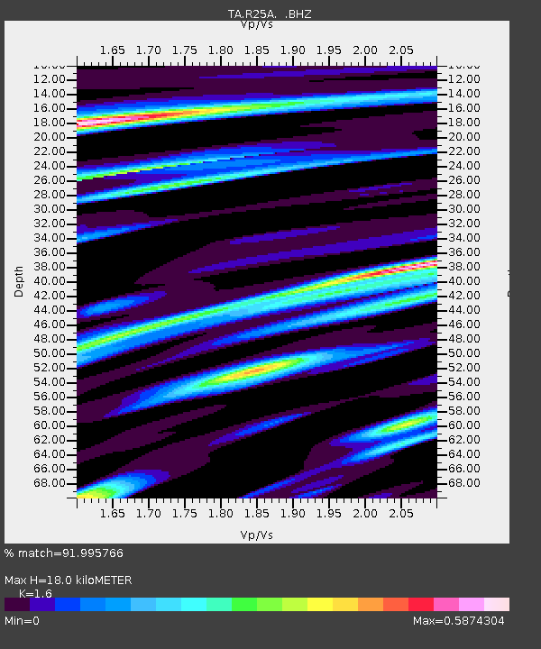
| Estimated Moho Depth: |
18.0 km |
| Estimated Crust Vp/Vs: |
1.60 |
| Assumed Crust Vp: |
6.159 km/s |
| Estimated Crust Vs: |
3.849 km/s |
| Estimated Crust Poisson's Ratio: |
0.18 |
|
| Radial Match: |
91.995766 % |
| Radial Bump: |
400 |
| Transverse Match: |
85.969574 % |
| Transverse Bump: |
400 |
| SOD ConfigId: |
2622 |
| Insert Time: |
2010-03-06 20:17:19.752 +0000 |
| GWidth: |
2.5 |
| Max Bumps: |
400 |
| Tol: |
0.001 |
|

Signal To Noise
| Channel | StoN | STA | LTA |
| TA:R25A: :BHZ:20090809T11:07:43.274001Z | 92.94043 | 5.4509137E-6 | 5.864954E-8 |
| TA:R25A: :BHN:20090809T11:07:43.274001Z | 23.496605 | 1.3219606E-6 | 5.6261772E-8 |
| TA:R25A: :BHE:20090809T11:07:43.274001Z | 15.107487 | 9.964433E-7 | 6.5956925E-8 |
| Arrivals |
| Ps | 1.8 SECOND |
| PpPs | 7.4 SECOND |
| PsPs/PpSs | 9.2 SECOND |


