You are here: Home > Network List > LD - Lamont-Doherty Cooperative Seismographic Network Stations List
> Station UNH University of New Hampshire, Durham, NH, USA > Earthquake Result Viewer
UNH University of New Hampshire, Durham, NH, USA - Earthquake Result Viewer
| Earthquake location: |
Peru-Ecuador Border Region |
| Earthquake latitude/longitude: |
-2.2/-77.0 |
| Earthquake time(UTC): |
2019/02/22 (053) 10:17:22 GMT |
| Earthquake Depth: |
132 km |
| Earthquake Magnitude: |
7.5 mww |
| Earthquake Catalog/Contributor: |
NEIC PDE/us |
|
| Network: |
LD Lamont-Doherty Cooperative Seismographic Network |
| Station: |
UNH University of New Hampshire, Durham, NH, USA |
| Lat/Lon: |
43.09 N/70.87 W |
| Elevation: |
5.0 m |
|
| Distance: |
45.4 deg |
| Az: |
6.333 deg |
| Baz: |
188.655 deg |
| Ray Param: |
0.07081357 |
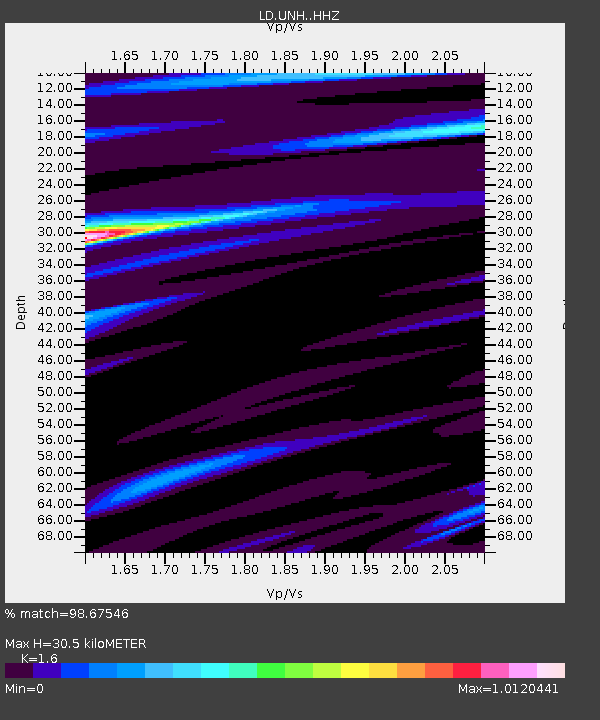
| Estimated Moho Depth: |
30.5 km |
| Estimated Crust Vp/Vs: |
1.60 |
| Assumed Crust Vp: |
6.419 km/s |
| Estimated Crust Vs: |
4.012 km/s |
| Estimated Crust Poisson's Ratio: |
0.18 |
|
| Radial Match: |
98.67546 % |
| Radial Bump: |
280 |
| Transverse Match: |
89.33192 % |
| Transverse Bump: |
400 |
| SOD ConfigId: |
13570011 |
| Insert Time: |
2019-05-02 13:59:44.441 +0000 |
| GWidth: |
2.5 |
| Max Bumps: |
400 |
| Tol: |
0.001 |
|

Signal To Noise
| Channel | StoN | STA | LTA |
| LD:UNH: :HHZ:20190222T10:24:57.464993Z | 24.023571 | 1.3726234E-5 | 5.7136526E-7 |
| LD:UNH: :HHN:20190222T10:24:57.464993Z | 24.185396 | 9.5598025E-6 | 3.952717E-7 |
| LD:UNH: :HHE:20190222T10:24:57.464993Z | 1.8898191 | 7.3055037E-7 | 3.865716E-7 |
| Arrivals |
| Ps | 3.1 SECOND |
| PpPs | 12 SECOND |
| PsPs/PpSs | 15 SECOND |


