You are here: Home > Network List > LM - Michigan State University Seismic Network Stations List
> Station L48A N Adams, MI, USA > Earthquake Result Viewer
L48A N Adams, MI, USA - Earthquake Result Viewer
| Earthquake location: |
Peru-Ecuador Border Region |
| Earthquake latitude/longitude: |
-2.2/-77.0 |
| Earthquake time(UTC): |
2019/02/22 (053) 10:17:22 GMT |
| Earthquake Depth: |
132 km |
| Earthquake Magnitude: |
7.5 mww |
| Earthquake Catalog/Contributor: |
NEIC PDE/us |
|
| Network: |
LM Michigan State University Seismic Network |
| Station: |
L48A N Adams, MI, USA |
| Lat/Lon: |
41.94 N/84.43 W |
| Elevation: |
369 m |
|
| Distance: |
44.4 deg |
| Az: |
352.103 deg |
| Baz: |
169.395 deg |
| Ray Param: |
0.07143712 |
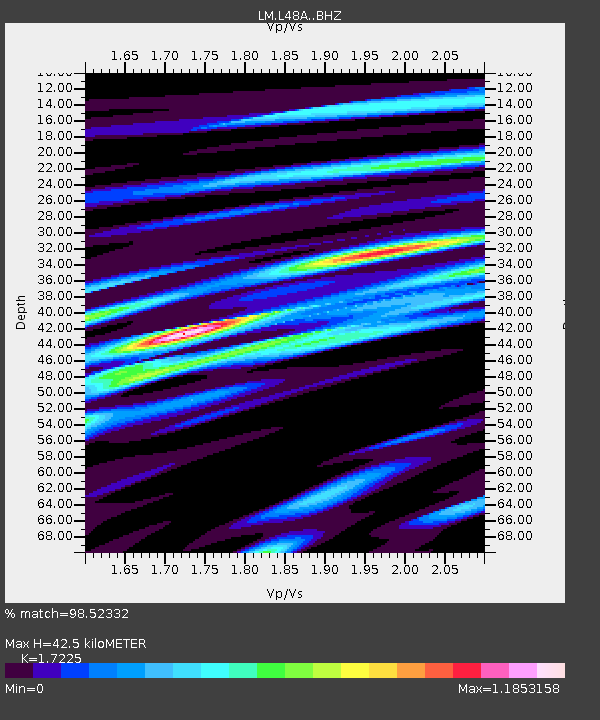
| Estimated Moho Depth: |
42.5 km |
| Estimated Crust Vp/Vs: |
1.72 |
| Assumed Crust Vp: |
6.498 km/s |
| Estimated Crust Vs: |
3.772 km/s |
| Estimated Crust Poisson's Ratio: |
0.25 |
|
| Radial Match: |
98.52332 % |
| Radial Bump: |
390 |
| Transverse Match: |
95.40925 % |
| Transverse Bump: |
400 |
| SOD ConfigId: |
13570011 |
| Insert Time: |
2019-05-02 13:59:47.197 +0000 |
| GWidth: |
2.5 |
| Max Bumps: |
400 |
| Tol: |
0.001 |
|

Signal To Noise
| Channel | StoN | STA | LTA |
| LM:L48A: :BHZ:20190222T10:24:49.749996Z | 65.741615 | 1.684364E-5 | 2.562097E-7 |
| LM:L48A: :BHN:20190222T10:24:49.749996Z | 29.423592 | 1.1190954E-5 | 3.803395E-7 |
| LM:L48A: :BHE:20190222T10:24:49.749996Z | 5.692974 | 1.4301874E-6 | 2.5121972E-7 |
| Arrivals |
| Ps | 5.1 SECOND |
| PpPs | 17 SECOND |
| PsPs/PpSs | 22 SECOND |


