You are here: Home > Network List > MU - Miami University Seismic Network Stations List
> Station MUG1 Guernsy > Earthquake Result Viewer
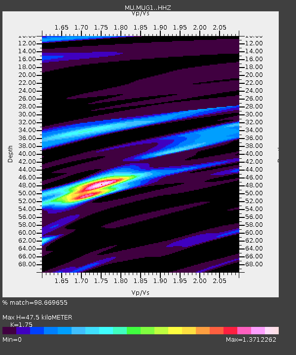
MUG1 Guernsy - Earthquake Result Viewer
| Earthquake location: |
Peru-Ecuador Border Region |
| Earthquake latitude/longitude: |
-2.2/-77.0 |
| Earthquake time(UTC): |
2019/02/22 (053) 10:17:22 GMT |
| Earthquake Depth: |
132 km |
| Earthquake Magnitude: |
7.5 mww |
| Earthquake Catalog/Contributor: |
NEIC PDE/us |
|
| Network: |
MU Miami University Seismic Network |
| Station: |
MUG1 Guernsy |
| Lat/Lon: |
40.11 N/81.29 W |
| Elevation: |
368 m |
|
| Distance: |
42.3 deg |
| Az: |
355.131 deg |
| Baz: |
173.651 deg |
| Ray Param: |
0.07279652 |
| Estimated Moho Depth: |
47.5 km |
| Estimated Crust Vp/Vs: |
1.75 |
| Assumed Crust Vp: |
6.483 km/s |
| Estimated Crust Vs: |
3.704 km/s |
| Estimated Crust Poisson's Ratio: |
0.26 |
|
| Radial Match: |
98.669655 % |
| Radial Bump: |
269 |
| Transverse Match: |
93.27781 % |
| Transverse Bump: |
400 |
| SOD ConfigId: |
13570011 |
| Insert Time: |
2019-05-02 13:59:55.641 +0000 |
| GWidth: |
2.5 |
| Max Bumps: |
400 |
| Tol: |
0.001 |
|

Signal To Noise
| Channel | StoN | STA | LTA |
| MU:MUG1: :HHZ:20190222T10:24:32.450009Z | 70.80062 | 4.8327547E-5 | 6.825865E-7 |
| MU:MUG1: :HHN:20190222T10:24:32.450009Z | 17.805233 | 2.073911E-5 | 1.1647761E-6 |
| MU:MUG1: :HHE:20190222T10:24:32.450009Z | 2.9943616 | 2.662623E-6 | 8.892122E-7 |
| Arrivals |
| Ps | 5.9 SECOND |
| PpPs | 19 SECOND |
| PsPs/PpSs | 25 SECOND |


