You are here: Home > Network List > MU - Miami University Seismic Network Stations List
> Station MUM1 Monroe > Earthquake Result Viewer
MUM1 Monroe - Earthquake Result Viewer
| Earthquake location: |
Peru-Ecuador Border Region |
| Earthquake latitude/longitude: |
-2.2/-77.0 |
| Earthquake time(UTC): |
2019/02/22 (053) 10:17:22 GMT |
| Earthquake Depth: |
132 km |
| Earthquake Magnitude: |
7.5 mww |
| Earthquake Catalog/Contributor: |
NEIC PDE/us |
|
| Network: |
MU Miami University Seismic Network |
| Station: |
MUM1 Monroe |
| Lat/Lon: |
39.65 N/81.15 W |
| Elevation: |
310 m |
|
| Distance: |
41.8 deg |
| Az: |
355.216 deg |
| Baz: |
173.804 deg |
| Ray Param: |
0.07308744 |
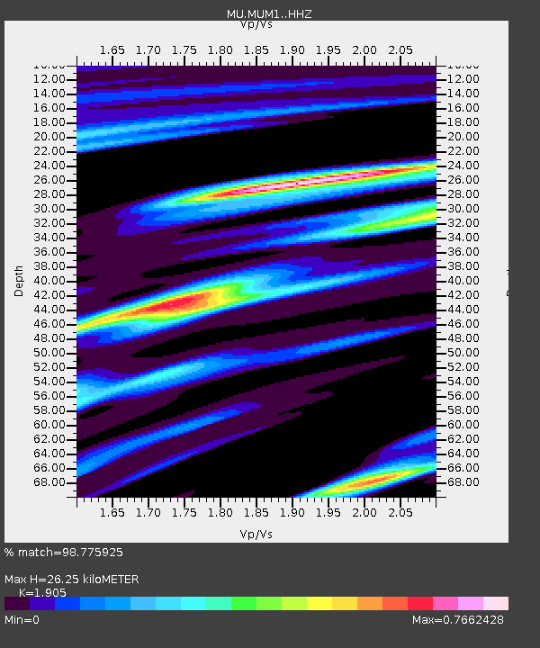
| Estimated Moho Depth: |
26.25 km |
| Estimated Crust Vp/Vs: |
1.90 |
| Assumed Crust Vp: |
6.207 km/s |
| Estimated Crust Vs: |
3.258 km/s |
| Estimated Crust Poisson's Ratio: |
0.31 |
|
| Radial Match: |
98.775925 % |
| Radial Bump: |
238 |
| Transverse Match: |
95.88486 % |
| Transverse Bump: |
400 |
| SOD ConfigId: |
13570011 |
| Insert Time: |
2019-05-02 13:59:56.728 +0000 |
| GWidth: |
2.5 |
| Max Bumps: |
400 |
| Tol: |
0.001 |
|

Signal To Noise
| Channel | StoN | STA | LTA |
| MU:MUM1: :HHZ:20190222T10:24:28.630001Z | 41.21943 | 4.59291E-5 | 1.1142585E-6 |
| MU:MUM1: :HHN:20190222T10:24:28.630001Z | 21.329567 | 2.3770532E-5 | 1.1144405E-6 |
| MU:MUM1: :HHE:20190222T10:24:28.630001Z | 4.5618095 | 4.1841527E-6 | 9.1721336E-7 |
| Arrivals |
| Ps | 4.1 SECOND |
| PpPs | 12 SECOND |
| PsPs/PpSs | 16 SECOND |


