You are here: Home > Network List > TA - USArray Transportable Network (new EarthScope stations) Stations List
> Station R25A Fountain Ranch, Boone, CO, USA > Earthquake Result Viewer
R25A Fountain Ranch, Boone, CO, USA - Earthquake Result Viewer

| Earthquake location: |
Sea Of Okhotsk |
| Earthquake latitude/longitude: |
54.2/154.3 |
| Earthquake time(UTC): |
2008/11/24 (329) 09:02:58 GMT |
| Earthquake Depth: |
492 km |
| Earthquake Magnitude: |
6.5 MB, 7.3 MW, 7.3 MW |
| Earthquake Catalog/Contributor: |
WHDF/NEIC |
|
| Network: |
TA USArray Transportable Network (new EarthScope stations) |
| Station: |
R25A Fountain Ranch, Boone, CO, USA |
| Lat/Lon: |
38.15 N/104.28 W |
| Elevation: |
1461 m |
|
| Distance: |
66.0 deg |
| Az: |
57.762 deg |
| Baz: |
320.93 deg |
| Ray Param: |
0.056169327 |
| Estimated Moho Depth: |
38.25 km |
| Estimated Crust Vp/Vs: |
2.07 |
| Assumed Crust Vp: |
6.159 km/s |
| Estimated Crust Vs: |
2.982 km/s |
| Estimated Crust Poisson's Ratio: |
0.35 |
|
| Radial Match: |
91.32064 % |
| Radial Bump: |
209 |
| Transverse Match: |
78.3899 % |
| Transverse Bump: |
316 |
| SOD ConfigId: |
2658 |
| Insert Time: |
2010-03-06 20:17:39.899 +0000 |
| GWidth: |
2.5 |
| Max Bumps: |
400 |
| Tol: |
0.001 |
|
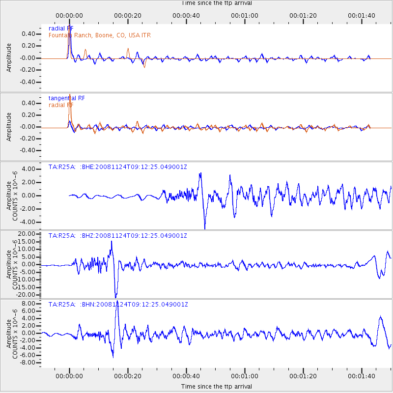
Signal To Noise
| Channel | StoN | STA | LTA |
| TA:R25A: :BHZ:20081124T09:12:25.049001Z | 9.1126995 | 2.352048E-6 | 2.581066E-7 |
| TA:R25A: :BHN:20081124T09:12:25.049001Z | 2.9146411 | 9.872258E-7 | 3.3871265E-7 |
| TA:R25A: :BHE:20081124T09:12:25.049001Z | 2.2849114 | 4.441298E-7 | 1.9437506E-7 |
| Arrivals |
| Ps | 6.8 SECOND |
| PpPs | 18 SECOND |
| PsPs/PpSs | 25 SECOND |


