You are here: Home > Network List > N4 - Central and EAstern US Network Stations List
> Station V53A Sandy Mush, NC, USA > Earthquake Result Viewer
V53A Sandy Mush, NC, USA - Earthquake Result Viewer
| Earthquake location: |
Peru-Ecuador Border Region |
| Earthquake latitude/longitude: |
-2.2/-77.0 |
| Earthquake time(UTC): |
2019/02/22 (053) 10:17:22 GMT |
| Earthquake Depth: |
132 km |
| Earthquake Magnitude: |
7.5 mww |
| Earthquake Catalog/Contributor: |
NEIC PDE/us |
|
| Network: |
N4 Central and EAstern US Network |
| Station: |
V53A Sandy Mush, NC, USA |
| Lat/Lon: |
35.67 N/82.81 W |
| Elevation: |
681 m |
|
| Distance: |
38.1 deg |
| Az: |
352.344 deg |
| Baz: |
170.59 deg |
| Ray Param: |
0.07531236 |
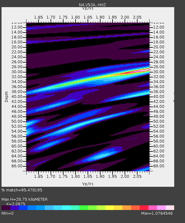
| Estimated Moho Depth: |
28.75 km |
| Estimated Crust Vp/Vs: |
2.10 |
| Assumed Crust Vp: |
6.35 km/s |
| Estimated Crust Vs: |
3.027 km/s |
| Estimated Crust Poisson's Ratio: |
0.35 |
|
| Radial Match: |
95.478195 % |
| Radial Bump: |
303 |
| Transverse Match: |
73.5302 % |
| Transverse Bump: |
400 |
| SOD ConfigId: |
13570011 |
| Insert Time: |
2019-05-02 14:01:26.138 +0000 |
| GWidth: |
2.5 |
| Max Bumps: |
400 |
| Tol: |
0.001 |
|

Signal To Noise
| Channel | StoN | STA | LTA |
| N4:V53A: :HHZ:20190222T10:23:57.67001Z | 58.55397 | 1.2969782E-5 | 2.2150131E-7 |
| N4:V53A: :HHN:20190222T10:23:57.67001Z | 50.608913 | 7.6011283E-6 | 1.5019347E-7 |
| N4:V53A: :HHE:20190222T10:23:57.67001Z | 9.815623 | 1.2379006E-6 | 1.2611534E-7 |
| Arrivals |
| Ps | 5.3 SECOND |
| PpPs | 13 SECOND |
| PsPs/PpSs | 18 SECOND |


