You are here: Home > Network List > NN - Western Great Basin/Eastern Sierra Nevada Stations List
> Station GMN Gold Mountain, NV, USA > Earthquake Result Viewer
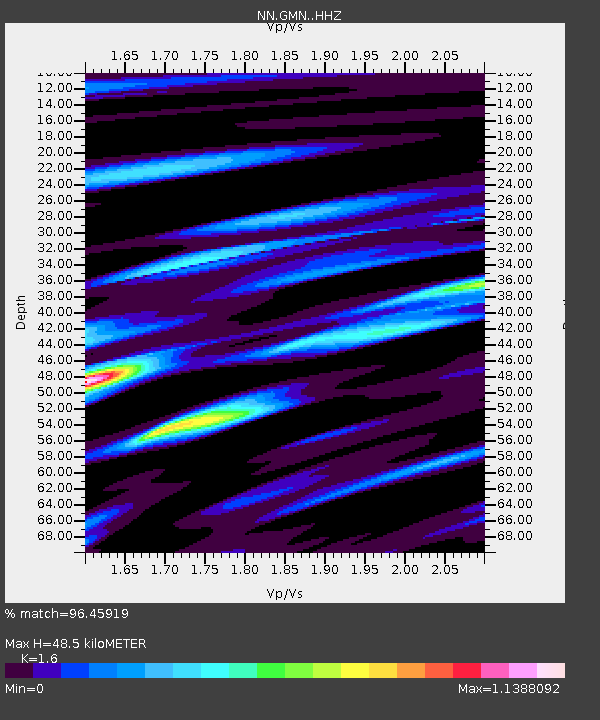
GMN Gold Mountain, NV, USA - Earthquake Result Viewer
| Earthquake location: |
Peru-Ecuador Border Region |
| Earthquake latitude/longitude: |
-2.2/-77.0 |
| Earthquake time(UTC): |
2019/02/22 (053) 10:17:22 GMT |
| Earthquake Depth: |
132 km |
| Earthquake Magnitude: |
7.5 mww |
| Earthquake Catalog/Contributor: |
NEIC PDE/us |
|
| Network: |
NN Western Great Basin/Eastern Sierra Nevada |
| Station: |
GMN Gold Mountain, NV, USA |
| Lat/Lon: |
37.30 N/117.26 W |
| Elevation: |
2168 m |
|
| Distance: |
54.2 deg |
| Az: |
320.559 deg |
| Baz: |
127.241 deg |
| Ray Param: |
0.065195024 |
| Estimated Moho Depth: |
48.5 km |
| Estimated Crust Vp/Vs: |
1.60 |
| Assumed Crust Vp: |
6.279 km/s |
| Estimated Crust Vs: |
3.924 km/s |
| Estimated Crust Poisson's Ratio: |
0.18 |
|
| Radial Match: |
96.45919 % |
| Radial Bump: |
400 |
| Transverse Match: |
86.4646 % |
| Transverse Bump: |
400 |
| SOD ConfigId: |
13570011 |
| Insert Time: |
2019-05-02 14:01:51.950 +0000 |
| GWidth: |
2.5 |
| Max Bumps: |
400 |
| Tol: |
0.001 |
|

Signal To Noise
| Channel | StoN | STA | LTA |
| NN:GMN: :HHZ:20190222T10:26:03.475002Z | 13.446717 | 1.5049927E-6 | 1.1192269E-7 |
| NN:GMN: :HHN:20190222T10:26:03.475002Z | 3.7893434 | 9.588933E-7 | 2.5305002E-7 |
| NN:GMN: :HHE:20190222T10:26:03.475002Z | 2.845381 | 6.051699E-7 | 2.12685E-7 |
| Arrivals |
| Ps | 4.9 SECOND |
| PpPs | 19 SECOND |
| PsPs/PpSs | 24 SECOND |


