You are here: Home > Network List > NN - Western Great Basin/Eastern Sierra Nevada Stations List
> Station MZPB Montezuma,NV,USA analog reactivation > Earthquake Result Viewer
MZPB Montezuma,NV,USA analog reactivation - Earthquake Result Viewer
| Earthquake location: |
Peru-Ecuador Border Region |
| Earthquake latitude/longitude: |
-2.2/-77.0 |
| Earthquake time(UTC): |
2019/02/22 (053) 10:17:22 GMT |
| Earthquake Depth: |
132 km |
| Earthquake Magnitude: |
7.5 mww |
| Earthquake Catalog/Contributor: |
NEIC PDE/us |
|
| Network: |
NN Western Great Basin/Eastern Sierra Nevada |
| Station: |
MZPB Montezuma,NV,USA analog reactivation |
| Lat/Lon: |
37.70 N/117.38 W |
| Elevation: |
2371 m |
|
| Distance: |
54.5 deg |
| Az: |
320.877 deg |
| Baz: |
127.352 deg |
| Ray Param: |
0.06498298 |
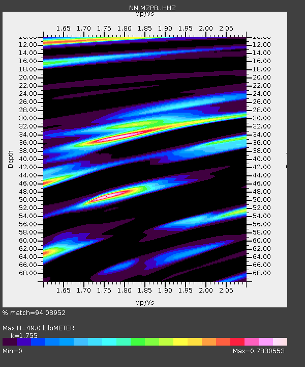
| Estimated Moho Depth: |
49.0 km |
| Estimated Crust Vp/Vs: |
1.75 |
| Assumed Crust Vp: |
6.279 km/s |
| Estimated Crust Vs: |
3.578 km/s |
| Estimated Crust Poisson's Ratio: |
0.26 |
|
| Radial Match: |
94.08952 % |
| Radial Bump: |
300 |
| Transverse Match: |
90.56723 % |
| Transverse Bump: |
400 |
| SOD ConfigId: |
13570011 |
| Insert Time: |
2019-05-02 14:01:55.083 +0000 |
| GWidth: |
2.5 |
| Max Bumps: |
400 |
| Tol: |
0.001 |
|

Signal To Noise
| Channel | StoN | STA | LTA |
| NN:MZPB: :HHZ:20190222T10:26:05.785Z | 11.347184 | 1.4269056E-6 | 1.2574975E-7 |
| NN:MZPB: :HHN:20190222T10:26:05.785Z | 2.6447115 | 3.7583504E-7 | 1.4210815E-7 |
| NN:MZPB: :HHE:20190222T10:26:05.785Z | 4.8169017 | 7.6890393E-7 | 1.5962624E-7 |
| Arrivals |
| Ps | 6.2 SECOND |
| PpPs | 20 SECOND |
| PsPs/PpSs | 27 SECOND |


