You are here: Home > Network List > OX - North-East Italy Seismic Network Stations List
> Station CGRP Cima Grappa > Earthquake Result Viewer
CGRP Cima Grappa - Earthquake Result Viewer
| Earthquake location: |
Peru-Ecuador Border Region |
| Earthquake latitude/longitude: |
-2.2/-77.0 |
| Earthquake time(UTC): |
2019/02/22 (053) 10:17:22 GMT |
| Earthquake Depth: |
132 km |
| Earthquake Magnitude: |
7.5 mww |
| Earthquake Catalog/Contributor: |
NEIC PDE/us |
|
| Network: |
OX North-East Italy Seismic Network |
| Station: |
CGRP Cima Grappa |
| Lat/Lon: |
45.88 N/11.80 E |
| Elevation: |
1757 m |
|
| Distance: |
90.7 deg |
| Az: |
44.305 deg |
| Baz: |
267.636 deg |
| Ray Param: |
0.04162435 |
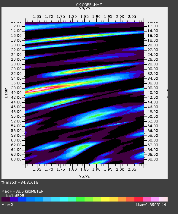
| Estimated Moho Depth: |
38.5 km |
| Estimated Crust Vp/Vs: |
1.65 |
| Assumed Crust Vp: |
6.155 km/s |
| Estimated Crust Vs: |
3.725 km/s |
| Estimated Crust Poisson's Ratio: |
0.21 |
|
| Radial Match: |
84.31618 % |
| Radial Bump: |
400 |
| Transverse Match: |
86.76185 % |
| Transverse Bump: |
400 |
| SOD ConfigId: |
13570011 |
| Insert Time: |
2019-05-02 14:02:49.493 +0000 |
| GWidth: |
2.5 |
| Max Bumps: |
400 |
| Tol: |
0.001 |
|

Signal To Noise
| Channel | StoN | STA | LTA |
| OX:CGRP: :HHZ:20190222T10:29:39.147976Z | 21.054817 | 7.4755053E-6 | 3.5504965E-7 |
| OX:CGRP: :HHN:20190222T10:29:39.147976Z | 4.2377105 | 1.2589861E-6 | 2.970911E-7 |
| OX:CGRP: :HHE:20190222T10:29:39.147976Z | 7.644478 | 2.5433442E-6 | 3.3270345E-7 |
| Arrivals |
| Ps | 4.2 SECOND |
| PpPs | 16 SECOND |
| PsPs/PpSs | 20 SECOND |


