You are here: Home > Network List > RV - Regional Alberta Seismic Observatory for Earthquake Studies Network Stations List
> Station HSPGA Hill Springs, AB > Earthquake Result Viewer
HSPGA Hill Springs, AB - Earthquake Result Viewer
| Earthquake location: |
Peru-Ecuador Border Region |
| Earthquake latitude/longitude: |
-2.2/-77.0 |
| Earthquake time(UTC): |
2019/02/22 (053) 10:17:22 GMT |
| Earthquake Depth: |
132 km |
| Earthquake Magnitude: |
7.5 mww |
| Earthquake Catalog/Contributor: |
NEIC PDE/us |
|
| Network: |
RV Regional Alberta Seismic Observatory for Earthquake Studies Network |
| Station: |
HSPGA Hill Springs, AB |
| Lat/Lon: |
49.36 N/113.65 W |
| Elevation: |
1155 m |
|
| Distance: |
60.3 deg |
| Az: |
333.314 deg |
| Baz: |
136.656 deg |
| Ray Param: |
0.061225105 |
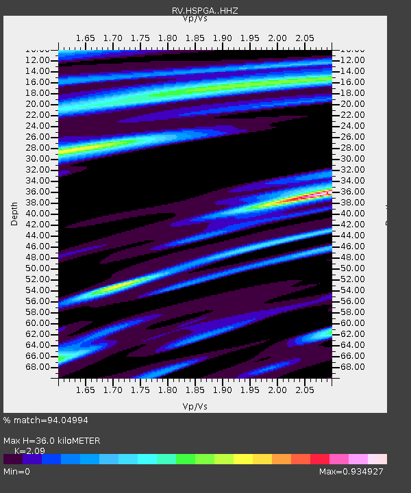
| Estimated Moho Depth: |
36.0 km |
| Estimated Crust Vp/Vs: |
2.09 |
| Assumed Crust Vp: |
6.178 km/s |
| Estimated Crust Vs: |
2.956 km/s |
| Estimated Crust Poisson's Ratio: |
0.35 |
|
| Radial Match: |
94.04994 % |
| Radial Bump: |
400 |
| Transverse Match: |
88.04143 % |
| Transverse Bump: |
400 |
| SOD ConfigId: |
13570011 |
| Insert Time: |
2019-05-02 14:04:55.736 +0000 |
| GWidth: |
2.5 |
| Max Bumps: |
400 |
| Tol: |
0.001 |
|

Signal To Noise
| Channel | StoN | STA | LTA |
| RV:HSPGA: :HHZ:20190222T10:26:46.360012Z | 12.125476 | 5.5630517E-6 | 4.5879037E-7 |
| RV:HSPGA: :HHN:20190222T10:26:46.360012Z | 2.5537713 | 1.1859872E-6 | 4.644062E-7 |
| RV:HSPGA: :HHE:20190222T10:26:46.360012Z | 3.6044643 | 1.4382389E-6 | 3.99016E-7 |
| Arrivals |
| Ps | 6.6 SECOND |
| PpPs | 17 SECOND |
| PsPs/PpSs | 24 SECOND |


