You are here: Home > Network List > TA - USArray Transportable Network (new EarthScope stations) Stations List
> Station 833A Chaparral WMA, Artesia Wells, TX, USA > Earthquake Result Viewer
833A Chaparral WMA, Artesia Wells, TX, USA - Earthquake Result Viewer

| Earthquake location: |
Peru-Ecuador Border Region |
| Earthquake latitude/longitude: |
-2.2/-77.0 |
| Earthquake time(UTC): |
2019/02/22 (053) 10:17:22 GMT |
| Earthquake Depth: |
132 km |
| Earthquake Magnitude: |
7.5 mww |
| Earthquake Catalog/Contributor: |
NEIC PDE/us |
|
| Network: |
TA USArray Transportable Network (new EarthScope stations) |
| Station: |
833A Chaparral WMA, Artesia Wells, TX, USA |
| Lat/Lon: |
28.32 N/99.39 W |
| Elevation: |
171 m |
|
| Distance: |
37.2 deg |
| Az: |
326.279 deg |
| Baz: |
141.005 deg |
| Ray Param: |
0.07581183 |
| Estimated Moho Depth: |
30.5 km |
| Estimated Crust Vp/Vs: |
1.83 |
| Assumed Crust Vp: |
6.347 km/s |
| Estimated Crust Vs: |
3.478 km/s |
| Estimated Crust Poisson's Ratio: |
0.29 |
|
| Radial Match: |
95.97883 % |
| Radial Bump: |
285 |
| Transverse Match: |
92.12011 % |
| Transverse Bump: |
400 |
| SOD ConfigId: |
13570011 |
| Insert Time: |
2019-05-02 14:05:08.074 +0000 |
| GWidth: |
2.5 |
| Max Bumps: |
400 |
| Tol: |
0.001 |
|
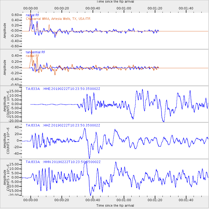
Signal To Noise
| Channel | StoN | STA | LTA |
| TA:833A: :HHZ:20190222T10:23:50.350002Z | 78.88094 | 1.2660231E-5 | 1.6049796E-7 |
| TA:833A: :HHN:20190222T10:23:50.350002Z | 23.824873 | 3.182863E-6 | 1.3359411E-7 |
| TA:833A: :HHE:20190222T10:23:50.350002Z | 8.904889 | 2.5374782E-6 | 2.8495336E-7 |
| Arrivals |
| Ps | 4.2 SECOND |
| PpPs | 13 SECOND |
| PsPs/PpSs | 17 SECOND |


