You are here: Home > Network List > TA - USArray Transportable Network (new EarthScope stations) Stations List
> Station A21K Barrow, AK, USA > Earthquake Result Viewer
A21K Barrow, AK, USA - Earthquake Result Viewer
| Earthquake location: |
Peru-Ecuador Border Region |
| Earthquake latitude/longitude: |
-2.2/-77.0 |
| Earthquake time(UTC): |
2019/02/22 (053) 10:17:22 GMT |
| Earthquake Depth: |
132 km |
| Earthquake Magnitude: |
7.5 mww |
| Earthquake Catalog/Contributor: |
NEIC PDE/us |
|
| Network: |
TA USArray Transportable Network (new EarthScope stations) |
| Station: |
A21K Barrow, AK, USA |
| Lat/Lon: |
71.32 N/156.62 W |
| Elevation: |
577 m |
|
| Distance: |
88.7 deg |
| Az: |
341.521 deg |
| Baz: |
100.555 deg |
| Ray Param: |
0.042081065 |
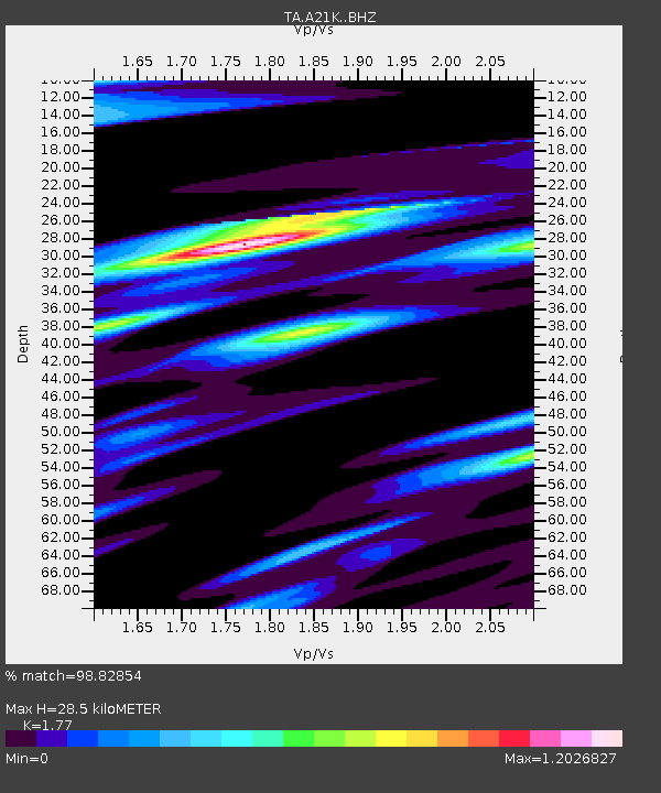
| Estimated Moho Depth: |
28.5 km |
| Estimated Crust Vp/Vs: |
1.77 |
| Assumed Crust Vp: |
6.048 km/s |
| Estimated Crust Vs: |
3.417 km/s |
| Estimated Crust Poisson's Ratio: |
0.27 |
|
| Radial Match: |
98.82854 % |
| Radial Bump: |
376 |
| Transverse Match: |
96.53809 % |
| Transverse Bump: |
400 |
| SOD ConfigId: |
13570011 |
| Insert Time: |
2019-05-02 14:05:08.192 +0000 |
| GWidth: |
2.5 |
| Max Bumps: |
400 |
| Tol: |
0.001 |
|

Signal To Noise
| Channel | StoN | STA | LTA |
| TA:A21K: :BHZ:20190222T10:29:29.850002Z | 22.024817 | 3.820398E-6 | 1.7345877E-7 |
| TA:A21K: :BHN:20190222T10:29:29.850002Z | 3.2910292 | 9.751886E-7 | 2.9631724E-7 |
| TA:A21K: :BHE:20190222T10:29:29.850002Z | 6.7755885 | 1.5832455E-6 | 2.3366908E-7 |
| Arrivals |
| Ps | 3.7 SECOND |
| PpPs | 13 SECOND |
| PsPs/PpSs | 17 SECOND |


