You are here: Home > Network List > TA - USArray Transportable Network (new EarthScope stations) Stations List
> Station C16K Lisburne Hills, AK, USA > Earthquake Result Viewer
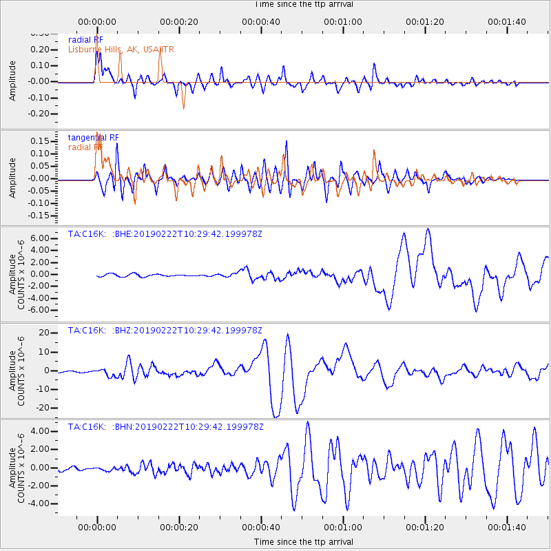
C16K Lisburne Hills, AK, USA - Earthquake Result Viewer
| Earthquake location: |
Peru-Ecuador Border Region |
| Earthquake latitude/longitude: |
-2.2/-77.0 |
| Earthquake time(UTC): |
2019/02/22 (053) 10:17:22 GMT |
| Earthquake Depth: |
132 km |
| Earthquake Magnitude: |
7.5 mww |
| Earthquake Catalog/Contributor: |
NEIC PDE/us |
|
| Network: |
TA USArray Transportable Network (new EarthScope stations) |
| Station: |
C16K Lisburne Hills, AK, USA |
| Lat/Lon: |
68.27 N/165.34 W |
| Elevation: |
102 m |
|
| Distance: |
91.4 deg |
| Az: |
338.145 deg |
| Baz: |
92.372 deg |
| Ray Param: |
0.041557543 |
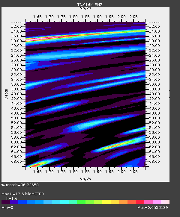
| Estimated Moho Depth: |
17.5 km |
| Estimated Crust Vp/Vs: |
1.60 |
| Assumed Crust Vp: |
5.906 km/s |
| Estimated Crust Vs: |
3.692 km/s |
| Estimated Crust Poisson's Ratio: |
0.18 |
|
| Radial Match: |
96.22658 % |
| Radial Bump: |
400 |
| Transverse Match: |
94.03858 % |
| Transverse Bump: |
400 |
| SOD ConfigId: |
13570011 |
| Insert Time: |
2019-05-02 14:05:13.363 +0000 |
| GWidth: |
2.5 |
| Max Bumps: |
400 |
| Tol: |
0.001 |
|
Signal To Noise
| Channel | StoN | STA | LTA |
| TA:C16K: :BHZ:20190222T10:29:42.199978Z | 6.721694 | 1.9605245E-6 | 2.916712E-7 |
| TA:C16K: :BHN:20190222T10:29:42.199978Z | 0.75642425 | 1.6325166E-7 | 2.1582022E-7 |
| TA:C16K: :BHE:20190222T10:29:42.199978Z | 1.5430609 | 3.2009012E-7 | 2.0743843E-7 |
| Arrivals |
| Ps | 1.8 SECOND |
| PpPs | 7.6 SECOND |
| PsPs/PpSs | 9.4 SECOND |


