You are here: Home > Network List > TA - USArray Transportable Network (new EarthScope stations) Stations List
> Station C18K Utukok River, AK, USA > Earthquake Result Viewer
C18K Utukok River, AK, USA - Earthquake Result Viewer
| Earthquake location: |
Peru-Ecuador Border Region |
| Earthquake latitude/longitude: |
-2.2/-77.0 |
| Earthquake time(UTC): |
2019/02/22 (053) 10:17:22 GMT |
| Earthquake Depth: |
132 km |
| Earthquake Magnitude: |
7.5 mww |
| Earthquake Catalog/Contributor: |
NEIC PDE/us |
|
| Network: |
TA USArray Transportable Network (new EarthScope stations) |
| Station: |
C18K Utukok River, AK, USA |
| Lat/Lon: |
68.65 N/161.19 W |
| Elevation: |
845 m |
|
| Distance: |
89.9 deg |
| Az: |
338.634 deg |
| Baz: |
96.223 deg |
| Ray Param: |
0.04168434 |
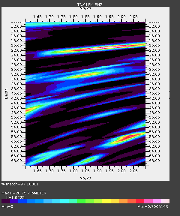
| Estimated Moho Depth: |
20.75 km |
| Estimated Crust Vp/Vs: |
1.92 |
| Assumed Crust Vp: |
5.906 km/s |
| Estimated Crust Vs: |
3.072 km/s |
| Estimated Crust Poisson's Ratio: |
0.31 |
|
| Radial Match: |
97.18881 % |
| Radial Bump: |
385 |
| Transverse Match: |
94.34704 % |
| Transverse Bump: |
400 |
| SOD ConfigId: |
13570011 |
| Insert Time: |
2019-05-02 14:05:13.831 +0000 |
| GWidth: |
2.5 |
| Max Bumps: |
400 |
| Tol: |
0.001 |
|

Signal To Noise
| Channel | StoN | STA | LTA |
| TA:C18K: :BHZ:20190222T10:29:35.250027Z | 8.712517 | 2.157056E-6 | 2.4758128E-7 |
| TA:C18K: :BHN:20190222T10:29:35.250027Z | 2.3762584 | 4.450604E-7 | 1.8729462E-7 |
| TA:C18K: :BHE:20190222T10:29:35.250027Z | 3.450095 | 7.397832E-7 | 2.1442402E-7 |
| Arrivals |
| Ps | 3.3 SECOND |
| PpPs | 10 SECOND |
| PsPs/PpSs | 13 SECOND |


