You are here: Home > Network List > WY - Yellowstone Wyoming Seismic Network Stations List
> Station YFT Old Faithful, YNP, WY, USA > Earthquake Result Viewer
YFT Old Faithful, YNP, WY, USA - Earthquake Result Viewer
| Earthquake location: |
Southeast Of Honshu, Japan |
| Earthquake latitude/longitude: |
30.5/142.1 |
| Earthquake time(UTC): |
2016/09/20 (264) 16:21:16 GMT |
| Earthquake Depth: |
10 km |
| Earthquake Magnitude: |
6.1 MWW, 6.0 MWB |
| Earthquake Catalog/Contributor: |
NEIC PDE/NEIC COMCAT |
|
| Network: |
WY Yellowstone Wyoming Seismic Network |
| Station: |
YFT Old Faithful, YNP, WY, USA |
| Lat/Lon: |
44.45 N/110.84 W |
| Elevation: |
2292 m |
|
| Distance: |
80.1 deg |
| Az: |
44.016 deg |
| Baz: |
303.167 deg |
| Ray Param: |
0.04848249 |
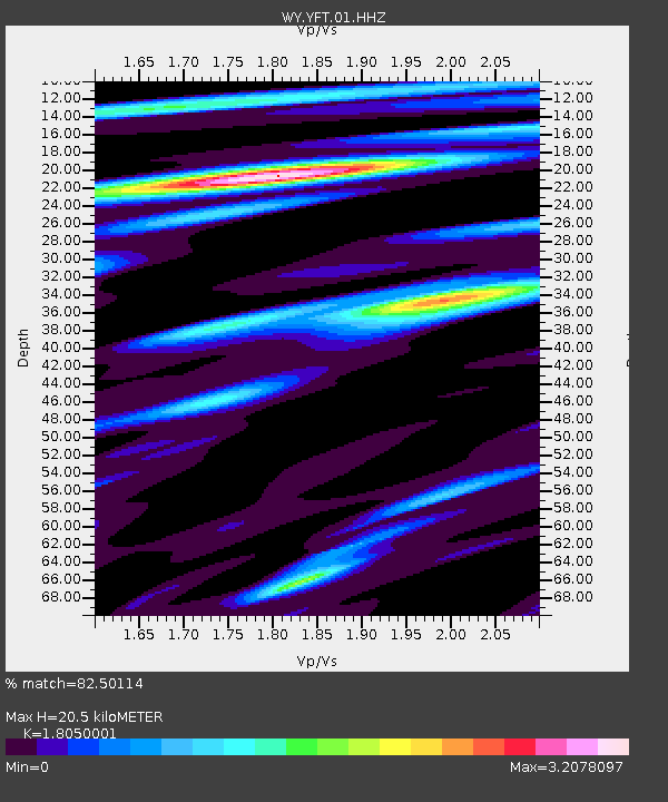
| Estimated Moho Depth: |
20.5 km |
| Estimated Crust Vp/Vs: |
1.81 |
| Assumed Crust Vp: |
6.35 km/s |
| Estimated Crust Vs: |
3.518 km/s |
| Estimated Crust Poisson's Ratio: |
0.28 |
|
| Radial Match: |
82.50114 % |
| Radial Bump: |
400 |
| Transverse Match: |
81.193565 % |
| Transverse Bump: |
400 |
| SOD ConfigId: |
1634031 |
| Insert Time: |
2016-10-04 16:30:16.534 +0000 |
| GWidth: |
2.5 |
| Max Bumps: |
400 |
| Tol: |
0.001 |
|

Signal To Noise
| Channel | StoN | STA | LTA |
| WY:YFT:01:HHZ:20160920T16:32:55.65999Z | 3.0062666 | 1.3422671E-8 | 4.464897E-9 |
| WY:YFT:01:HHN:20160920T16:32:55.65999Z | 1.2243881 | 4.5384123E-9 | 3.706678E-9 |
| WY:YFT:01:HHE:20160920T16:32:55.65999Z | 2.8659835 | 1.0030693E-8 | 3.499913E-9 |
| Arrivals |
| Ps | 2.7 SECOND |
| PpPs | 8.8 SECOND |
| PsPs/PpSs | 11 SECOND |


