You are here: Home > Network List > WY - Yellowstone Wyoming Seismic Network Stations List
> Station YNR Norris Junction, YNP, WY, USA > Earthquake Result Viewer
YNR Norris Junction, YNP, WY, USA - Earthquake Result Viewer

| Earthquake location: |
Southeast Of Honshu, Japan |
| Earthquake latitude/longitude: |
30.5/142.1 |
| Earthquake time(UTC): |
2016/09/20 (264) 16:21:16 GMT |
| Earthquake Depth: |
10 km |
| Earthquake Magnitude: |
6.1 MWW, 6.0 MWB |
| Earthquake Catalog/Contributor: |
NEIC PDE/NEIC COMCAT |
|
| Network: |
WY Yellowstone Wyoming Seismic Network |
| Station: |
YNR Norris Junction, YNP, WY, USA |
| Lat/Lon: |
44.72 N/110.68 W |
| Elevation: |
2336 m |
|
| Distance: |
80.1 deg |
| Az: |
43.729 deg |
| Baz: |
303.227 deg |
| Ray Param: |
0.048517328 |
| Estimated Moho Depth: |
20.75 km |
| Estimated Crust Vp/Vs: |
1.99 |
| Assumed Crust Vp: |
6.35 km/s |
| Estimated Crust Vs: |
3.199 km/s |
| Estimated Crust Poisson's Ratio: |
0.33 |
|
| Radial Match: |
86.17957 % |
| Radial Bump: |
400 |
| Transverse Match: |
70.09781 % |
| Transverse Bump: |
400 |
| SOD ConfigId: |
1634031 |
| Insert Time: |
2016-10-04 16:30:53.021 +0000 |
| GWidth: |
2.5 |
| Max Bumps: |
400 |
| Tol: |
0.001 |
|
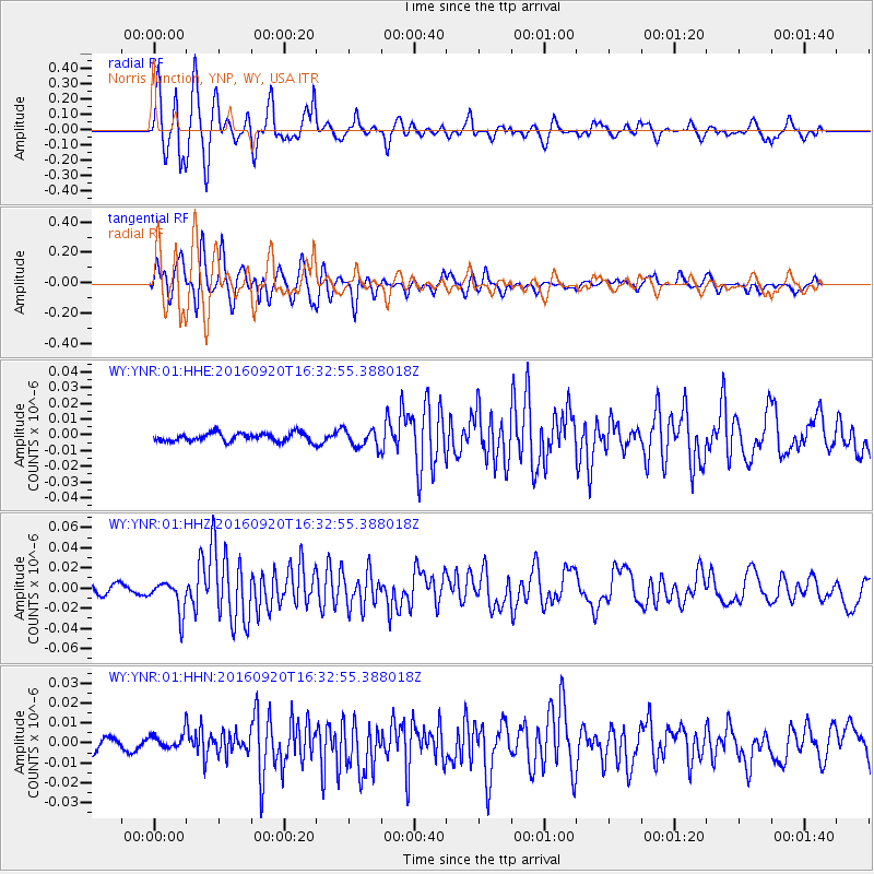
Signal To Noise
| Channel | StoN | STA | LTA |
| WY:YNR:01:HHZ:20160920T16:32:55.388018Z | 4.51029 | 1.5993402E-8 | 3.5459808E-9 |
| WY:YNR:01:HHN:20160920T16:32:55.388018Z | 0.70410854 | 3.3400416E-9 | 4.743646E-9 |
| WY:YNR:01:HHE:20160920T16:32:55.388018Z | 2.1273375 | 5.7055303E-9 | 2.6820053E-9 |
| Arrivals |
| Ps | 3.3 SECOND |
| PpPs | 9.5 SECOND |
| PsPs/PpSs | 13 SECOND |


