You are here: Home > Network List > TA - USArray Transportable Network (new EarthScope stations) Stations List
> Station J20K Nowitna River, AK, USA > Earthquake Result Viewer
J20K Nowitna River, AK, USA - Earthquake Result Viewer
| Earthquake location: |
Peru-Ecuador Border Region |
| Earthquake latitude/longitude: |
-2.2/-77.0 |
| Earthquake time(UTC): |
2019/02/22 (053) 10:17:22 GMT |
| Earthquake Depth: |
132 km |
| Earthquake Magnitude: |
7.5 mww |
| Earthquake Catalog/Contributor: |
NEIC PDE/us |
|
| Network: |
TA USArray Transportable Network (new EarthScope stations) |
| Station: |
J20K Nowitna River, AK, USA |
| Lat/Lon: |
64.18 N/154.15 W |
| Elevation: |
314 m |
|
| Distance: |
86.4 deg |
| Az: |
334.671 deg |
| Baz: |
102.552 deg |
| Ray Param: |
0.04380531 |
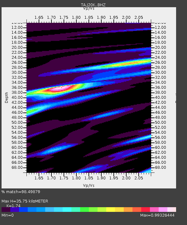
| Estimated Moho Depth: |
35.75 km |
| Estimated Crust Vp/Vs: |
1.74 |
| Assumed Crust Vp: |
6.566 km/s |
| Estimated Crust Vs: |
3.774 km/s |
| Estimated Crust Poisson's Ratio: |
0.25 |
|
| Radial Match: |
98.49879 % |
| Radial Bump: |
386 |
| Transverse Match: |
94.87045 % |
| Transverse Bump: |
400 |
| SOD ConfigId: |
13570011 |
| Insert Time: |
2019-05-02 14:06:13.378 +0000 |
| GWidth: |
2.5 |
| Max Bumps: |
400 |
| Tol: |
0.001 |
|

Signal To Noise
| Channel | StoN | STA | LTA |
| TA:J20K: :BHZ:20190222T10:29:18.574978Z | 14.538346 | 2.6021676E-6 | 1.789865E-7 |
| TA:J20K: :BHN:20190222T10:29:18.574978Z | 1.7716653 | 3.5668498E-7 | 2.0132751E-7 |
| TA:J20K: :BHE:20190222T10:29:18.574978Z | 6.062028 | 9.224565E-7 | 1.5216962E-7 |
| Arrivals |
| Ps | 4.1 SECOND |
| PpPs | 15 SECOND |
| PsPs/PpSs | 19 SECOND |


