You are here: Home > Network List > TA - USArray Transportable Network (new EarthScope stations) Stations List
> Station L20K Farewell, AK, USA > Earthquake Result Viewer
L20K Farewell, AK, USA - Earthquake Result Viewer
| Earthquake location: |
Peru-Ecuador Border Region |
| Earthquake latitude/longitude: |
-2.2/-77.0 |
| Earthquake time(UTC): |
2019/02/22 (053) 10:17:22 GMT |
| Earthquake Depth: |
132 km |
| Earthquake Magnitude: |
7.5 mww |
| Earthquake Catalog/Contributor: |
NEIC PDE/us |
|
| Network: |
TA USArray Transportable Network (new EarthScope stations) |
| Station: |
L20K Farewell, AK, USA |
| Lat/Lon: |
62.48 N/153.88 W |
| Elevation: |
673 m |
|
| Distance: |
85.9 deg |
| Az: |
333.03 deg |
| Baz: |
102.679 deg |
| Ray Param: |
0.044157043 |
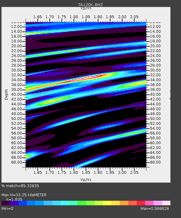
| Estimated Moho Depth: |
33.25 km |
| Estimated Crust Vp/Vs: |
1.84 |
| Assumed Crust Vp: |
6.566 km/s |
| Estimated Crust Vs: |
3.578 km/s |
| Estimated Crust Poisson's Ratio: |
0.29 |
|
| Radial Match: |
95.32635 % |
| Radial Bump: |
400 |
| Transverse Match: |
92.05287 % |
| Transverse Bump: |
400 |
| SOD ConfigId: |
13570011 |
| Insert Time: |
2019-05-02 14:06:27.608 +0000 |
| GWidth: |
2.5 |
| Max Bumps: |
400 |
| Tol: |
0.001 |
|

Signal To Noise
| Channel | StoN | STA | LTA |
| TA:L20K: :BHZ:20190222T10:29:16.175015Z | 9.910179 | 3.3236715E-6 | 3.3537955E-7 |
| TA:L20K: :BHN:20190222T10:29:16.175015Z | 1.8829836 | 5.306649E-7 | 2.8182131E-7 |
| TA:L20K: :BHE:20190222T10:29:16.175015Z | 3.459781 | 1.4495126E-6 | 4.189608E-7 |
| Arrivals |
| Ps | 4.3 SECOND |
| PpPs | 14 SECOND |
| PsPs/PpSs | 18 SECOND |


