You are here: Home > Network List > TA - USArray Transportable Network (new EarthScope stations) Stations List
> Station L61B Northampton, MA, USA > Earthquake Result Viewer
L61B Northampton, MA, USA - Earthquake Result Viewer
| Earthquake location: |
Peru-Ecuador Border Region |
| Earthquake latitude/longitude: |
-2.2/-77.0 |
| Earthquake time(UTC): |
2019/02/22 (053) 10:17:22 GMT |
| Earthquake Depth: |
132 km |
| Earthquake Magnitude: |
7.5 mww |
| Earthquake Catalog/Contributor: |
NEIC PDE/us |
|
| Network: |
TA USArray Transportable Network (new EarthScope stations) |
| Station: |
L61B Northampton, MA, USA |
| Lat/Lon: |
42.45 N/72.68 W |
| Elevation: |
261 m |
|
| Distance: |
44.6 deg |
| Az: |
4.577 deg |
| Baz: |
186.185 deg |
| Ray Param: |
0.0713277 |
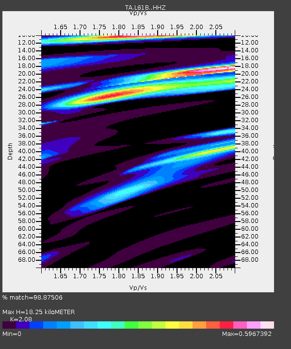
| Estimated Moho Depth: |
18.25 km |
| Estimated Crust Vp/Vs: |
2.08 |
| Assumed Crust Vp: |
6.419 km/s |
| Estimated Crust Vs: |
3.086 km/s |
| Estimated Crust Poisson's Ratio: |
0.35 |
|
| Radial Match: |
98.87506 % |
| Radial Bump: |
199 |
| Transverse Match: |
93.42062 % |
| Transverse Bump: |
400 |
| SOD ConfigId: |
13570011 |
| Insert Time: |
2019-05-02 14:06:30.820 +0000 |
| GWidth: |
2.5 |
| Max Bumps: |
400 |
| Tol: |
0.001 |
|

Signal To Noise
| Channel | StoN | STA | LTA |
| TA:L61B: :HHZ:20190222T10:24:51.080013Z | 28.937656 | 1.3877572E-5 | 4.795679E-7 |
| TA:L61B: :HHN:20190222T10:24:51.080013Z | 24.201174 | 9.678669E-6 | 3.999256E-7 |
| TA:L61B: :HHE:20190222T10:24:51.080013Z | 2.9424148 | 1.2301881E-6 | 4.1808795E-7 |
| Arrivals |
| Ps | 3.2 SECOND |
| PpPs | 8.3 SECOND |
| PsPs/PpSs | 12 SECOND |


