You are here: Home > Network List > TA - USArray Transportable Network (new EarthScope stations) Stations List
> Station P17K Kvichak River, AK, USA > Earthquake Result Viewer
P17K Kvichak River, AK, USA - Earthquake Result Viewer

| Earthquake location: |
Peru-Ecuador Border Region |
| Earthquake latitude/longitude: |
-2.2/-77.0 |
| Earthquake time(UTC): |
2019/02/22 (053) 10:17:22 GMT |
| Earthquake Depth: |
132 km |
| Earthquake Magnitude: |
7.5 mww |
| Earthquake Catalog/Contributor: |
NEIC PDE/us |
|
| Network: |
TA USArray Transportable Network (new EarthScope stations) |
| Station: |
P17K Kvichak River, AK, USA |
| Lat/Lon: |
59.20 N/156.44 W |
| Elevation: |
91 m |
|
| Distance: |
86.5 deg |
| Az: |
329.545 deg |
| Baz: |
100.214 deg |
| Ray Param: |
0.043743227 |
| Estimated Moho Depth: |
15.5 km |
| Estimated Crust Vp/Vs: |
2.09 |
| Assumed Crust Vp: |
6.276 km/s |
| Estimated Crust Vs: |
2.999 km/s |
| Estimated Crust Poisson's Ratio: |
0.35 |
|
| Radial Match: |
89.462296 % |
| Radial Bump: |
400 |
| Transverse Match: |
80.32016 % |
| Transverse Bump: |
400 |
| SOD ConfigId: |
13570011 |
| Insert Time: |
2019-05-02 14:06:57.455 +0000 |
| GWidth: |
2.5 |
| Max Bumps: |
400 |
| Tol: |
0.001 |
|
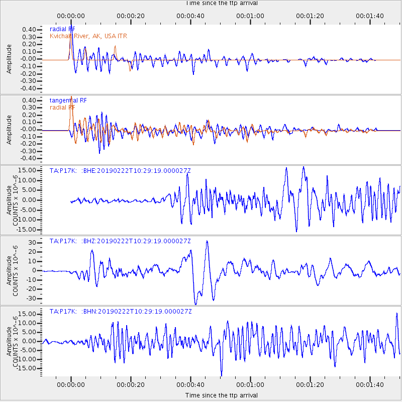
Signal To Noise
| Channel | StoN | STA | LTA |
| TA:P17K: :BHZ:20190222T10:29:19.000027Z | 12.672593 | 3.8835165E-6 | 3.0645E-7 |
| TA:P17K: :BHN:20190222T10:29:19.000027Z | 0.75229657 | 6.496068E-7 | 8.6349826E-7 |
| TA:P17K: :BHE:20190222T10:29:19.000027Z | 3.634695 | 2.0372406E-6 | 5.6049834E-7 |
| Arrivals |
| Ps | 2.7 SECOND |
| PpPs | 7.5 SECOND |
| PsPs/PpSs | 10 SECOND |


