You are here: Home > Network List > TA - USArray Transportable Network (new EarthScope stations) Stations List
> Station R32K Eaglecrest, AK, USA > Earthquake Result Viewer
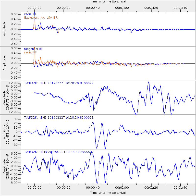
R32K Eaglecrest, AK, USA - Earthquake Result Viewer
*The percent match for this event was below the threshold and hence no stack was calculated.
| Earthquake location: |
Peru-Ecuador Border Region |
| Earthquake latitude/longitude: |
-2.2/-77.0 |
| Earthquake time(UTC): |
2019/02/22 (053) 10:17:22 GMT |
| Earthquake Depth: |
132 km |
| Earthquake Magnitude: |
7.5 mww |
| Earthquake Catalog/Contributor: |
NEIC PDE/us |
|
| Network: |
TA USArray Transportable Network (new EarthScope stations) |
| Station: |
R32K Eaglecrest, AK, USA |
| Lat/Lon: |
58.27 N/134.52 W |
| Elevation: |
386 m |
|
| Distance: |
75.4 deg |
| Az: |
332.586 deg |
| Baz: |
119.461 deg |
| Ray Param: |
$rayparam |
*The percent match for this event was below the threshold and hence was not used in the summary stack. |
|
| Radial Match: |
65.00029 % |
| Radial Bump: |
400 |
| Transverse Match: |
59.750534 % |
| Transverse Bump: |
400 |
| SOD ConfigId: |
13570011 |
| Insert Time: |
2019-05-02 14:07:10.230 +0000 |
| GWidth: |
2.5 |
| Max Bumps: |
400 |
| Tol: |
0.001 |
|
Signal To Noise
| Channel | StoN | STA | LTA |
| TA:R32K: :BHZ:20190222T10:28:20.850002Z | 3.8131018 | 4.2119586E-6 | 1.1046017E-6 |
| TA:R32K: :BHN:20190222T10:28:20.850002Z | 1.8334633 | 2.8895467E-6 | 1.5760047E-6 |
| TA:R32K: :BHE:20190222T10:28:20.850002Z | 0.96876734 | 2.7467975E-6 | 2.8353531E-6 |
| Arrivals |
| Ps | |
| PpPs | |
| PsPs/PpSs | |


