You are here: Home > Network List > TD - TransAlta Monitoring Network Stations List
> Station TD010 Z > Earthquake Result Viewer
TD010 Z - Earthquake Result Viewer
| Earthquake location: |
Peru-Ecuador Border Region |
| Earthquake latitude/longitude: |
-2.2/-77.0 |
| Earthquake time(UTC): |
2019/02/22 (053) 10:17:22 GMT |
| Earthquake Depth: |
132 km |
| Earthquake Magnitude: |
7.5 mww |
| Earthquake Catalog/Contributor: |
NEIC PDE/us |
|
| Network: |
TD TransAlta Monitoring Network |
| Station: |
TD010 Z |
| Lat/Lon: |
52.64 N/116.33 W |
| Elevation: |
1637 m |
|
| Distance: |
63.8 deg |
| Az: |
334.523 deg |
| Baz: |
135.144 deg |
| Ray Param: |
0.05893954 |
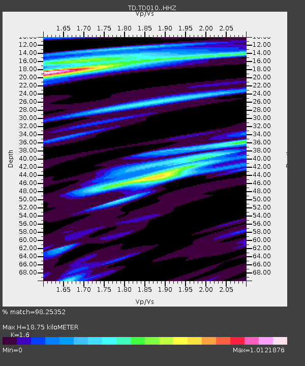
| Estimated Moho Depth: |
18.75 km |
| Estimated Crust Vp/Vs: |
1.60 |
| Assumed Crust Vp: |
6.142 km/s |
| Estimated Crust Vs: |
3.839 km/s |
| Estimated Crust Poisson's Ratio: |
0.18 |
|
| Radial Match: |
98.25352 % |
| Radial Bump: |
315 |
| Transverse Match: |
95.61957 % |
| Transverse Bump: |
380 |
| SOD ConfigId: |
13570011 |
| Insert Time: |
2019-05-02 14:07:21.782 +0000 |
| GWidth: |
2.5 |
| Max Bumps: |
400 |
| Tol: |
0.001 |
|

Signal To Noise
| Channel | StoN | STA | LTA |
| TD:TD010: :HHZ:20190222T10:27:09.910Z | 43.987926 | 1.3737503E-5 | 3.1230167E-7 |
| TD:TD010: :HH1:20190222T10:27:09.910Z | 20.921846 | 6.9606735E-6 | 3.3269885E-7 |
| TD:TD010: :HH2:20190222T10:27:09.910Z | 6.3079576 | 2.9193593E-6 | 4.6280576E-7 |
| Arrivals |
| Ps | 1.9 SECOND |
| PpPs | 7.6 SECOND |
| PsPs/PpSs | 9.5 SECOND |


