You are here: Home > Network List > TD - TransAlta Monitoring Network Stations List
> Station TD011 Z > Earthquake Result Viewer
TD011 Z - Earthquake Result Viewer
| Earthquake location: |
Peru-Ecuador Border Region |
| Earthquake latitude/longitude: |
-2.2/-77.0 |
| Earthquake time(UTC): |
2019/02/22 (053) 10:17:22 GMT |
| Earthquake Depth: |
132 km |
| Earthquake Magnitude: |
7.5 mww |
| Earthquake Catalog/Contributor: |
NEIC PDE/us |
|
| Network: |
TD TransAlta Monitoring Network |
| Station: |
TD011 Z |
| Lat/Lon: |
52.55 N/115.52 W |
| Elevation: |
1103 m |
|
| Distance: |
63.4 deg |
| Az: |
334.85 deg |
| Baz: |
135.937 deg |
| Ray Param: |
0.05920775 |
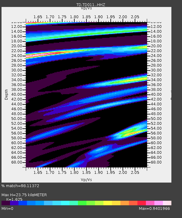
| Estimated Moho Depth: |
23.75 km |
| Estimated Crust Vp/Vs: |
1.62 |
| Assumed Crust Vp: |
6.426 km/s |
| Estimated Crust Vs: |
3.955 km/s |
| Estimated Crust Poisson's Ratio: |
0.20 |
|
| Radial Match: |
98.11372 % |
| Radial Bump: |
332 |
| Transverse Match: |
82.79426 % |
| Transverse Bump: |
400 |
| SOD ConfigId: |
13570011 |
| Insert Time: |
2019-05-02 14:07:24.956 +0000 |
| GWidth: |
2.5 |
| Max Bumps: |
400 |
| Tol: |
0.001 |
|

Signal To Noise
| Channel | StoN | STA | LTA |
| TD:TD011: :HHZ:20190222T10:27:07.209988Z | 25.55126 | 1.1466928E-5 | 4.4878132E-7 |
| TD:TD011: :HH1:20190222T10:27:07.209988Z | 4.781148 | 1.4689468E-6 | 3.0723726E-7 |
| TD:TD011: :HH2:20190222T10:27:07.209988Z | 8.952622 | 2.4896854E-6 | 2.7809563E-7 |
| Arrivals |
| Ps | 2.4 SECOND |
| PpPs | 9.3 SECOND |
| PsPs/PpSs | 12 SECOND |


