You are here: Home > Network List > TA - USArray Transportable Network (new EarthScope stations) Stations List
> Station K19A Absolon Red Butte, Lander, WY, USA > Earthquake Result Viewer
K19A Absolon Red Butte, Lander, WY, USA - Earthquake Result Viewer
| Earthquake location: |
Off East Coast Of Honshu, Japan |
| Earthquake latitude/longitude: |
37.6/142.2 |
| Earthquake time(UTC): |
2008/07/19 (201) 02:39:28 GMT |
| Earthquake Depth: |
22 km |
| Earthquake Magnitude: |
6.2 MB, 7.0 MS, 7.0 MW, 6.9 MW |
| Earthquake Catalog/Contributor: |
WHDF/NEIC |
|
| Network: |
TA USArray Transportable Network (new EarthScope stations) |
| Station: |
K19A Absolon Red Butte, Lander, WY, USA |
| Lat/Lon: |
42.82 N/108.85 W |
| Elevation: |
1878 m |
|
| Distance: |
77.2 deg |
| Az: |
45.526 deg |
| Baz: |
309.569 deg |
| Ray Param: |
0.05044996 |
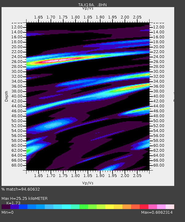
| Estimated Moho Depth: |
25.25 km |
| Estimated Crust Vp/Vs: |
1.73 |
| Assumed Crust Vp: |
6.161 km/s |
| Estimated Crust Vs: |
3.561 km/s |
| Estimated Crust Poisson's Ratio: |
0.25 |
|
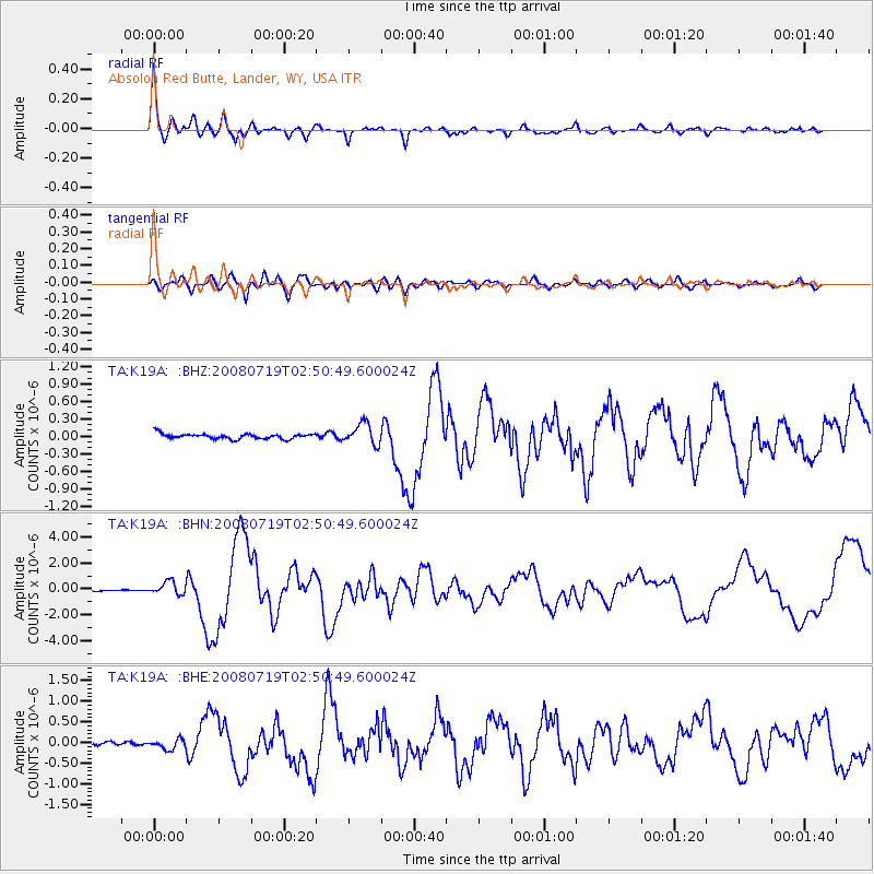
| Radial Match: |
94.60632 % |
| Radial Bump: |
400 |
| Transverse Match: |
77.9725 % |
| Transverse Bump: |
400 |
| SOD ConfigId: |
2504 |
| Insert Time: |
2010-03-06 20:19:42.436 +0000 |
| GWidth: |
2.5 |
| Max Bumps: |
400 |
| Tol: |
0.001 |
|
Signal To Noise
| Channel | StoN | STA | LTA |
| TA:K19A: :BHN:20080719T02:50:49.600024Z | 8.292534 | 5.173184E-7 | 6.238364E-8 |
| TA:K19A: :BHE:20080719T02:50:49.600024Z | 4.2056503 | 1.1760378E-7 | 2.7963281E-8 |
| TA:K19A: :BHZ:20080719T02:50:49.600024Z | 4.0722294 | 1.7980891E-7 | 4.415491E-8 |
| Arrivals |
| Ps | 3.1 SECOND |
| PpPs | 11 SECOND |
| PsPs/PpSs | 14 SECOND |


