You are here: Home > Network List > UW - Pacific Northwest Regional Seismic Network Stations List
> Station LCCR Mulino, OR, USA > Earthquake Result Viewer
LCCR Mulino, OR, USA - Earthquake Result Viewer
| Earthquake location: |
Peru-Ecuador Border Region |
| Earthquake latitude/longitude: |
-2.2/-77.0 |
| Earthquake time(UTC): |
2019/02/22 (053) 10:17:22 GMT |
| Earthquake Depth: |
132 km |
| Earthquake Magnitude: |
7.5 mww |
| Earthquake Catalog/Contributor: |
NEIC PDE/us |
|
| Network: |
UW Pacific Northwest Regional Seismic Network |
| Station: |
LCCR Mulino, OR, USA |
| Lat/Lon: |
45.21 N/122.48 W |
| Elevation: |
273 m |
|
| Distance: |
62.1 deg |
| Az: |
325.227 deg |
| Baz: |
126.277 deg |
| Ray Param: |
0.060088415 |
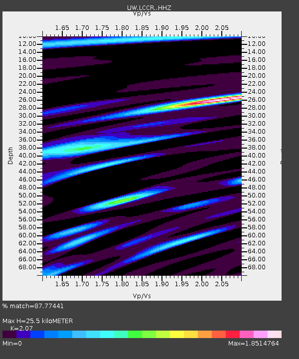
| Estimated Moho Depth: |
25.5 km |
| Estimated Crust Vp/Vs: |
2.07 |
| Assumed Crust Vp: |
6.566 km/s |
| Estimated Crust Vs: |
3.172 km/s |
| Estimated Crust Poisson's Ratio: |
0.35 |
|
| Radial Match: |
87.77441 % |
| Radial Bump: |
400 |
| Transverse Match: |
74.58107 % |
| Transverse Bump: |
400 |
| SOD ConfigId: |
13570011 |
| Insert Time: |
2019-05-02 14:08:21.498 +0000 |
| GWidth: |
2.5 |
| Max Bumps: |
400 |
| Tol: |
0.001 |
|

Signal To Noise
| Channel | StoN | STA | LTA |
| UW:LCCR: :HHZ:20190222T10:26:58.198025Z | 7.3702435 | 3.2188298E-6 | 4.3673316E-7 |
| UW:LCCR: :HHN:20190222T10:26:58.198025Z | 1.9899898 | 1.3312779E-6 | 6.689873E-7 |
| UW:LCCR: :HHE:20190222T10:26:58.198025Z | 3.109755 | 1.5787148E-6 | 5.0766533E-7 |
| Arrivals |
| Ps | 4.3 SECOND |
| PpPs | 11 SECOND |
| PsPs/PpSs | 16 SECOND |


