You are here: Home > Network List > UW - Pacific Northwest Regional Seismic Network Stations List
> Station LNO Lincton Mt., Oregon previous ISC code: LNOR > Earthquake Result Viewer
LNO Lincton Mt., Oregon previous ISC code: LNOR - Earthquake Result Viewer
| Earthquake location: |
Peru-Ecuador Border Region |
| Earthquake latitude/longitude: |
-2.2/-77.0 |
| Earthquake time(UTC): |
2019/02/22 (053) 10:17:22 GMT |
| Earthquake Depth: |
132 km |
| Earthquake Magnitude: |
7.5 mww |
| Earthquake Catalog/Contributor: |
NEIC PDE/us |
|
| Network: |
UW Pacific Northwest Regional Seismic Network |
| Station: |
LNO Lincton Mt., Oregon previous ISC code: LNOR |
| Lat/Lon: |
45.87 N/118.29 W |
| Elevation: |
771 m |
|
| Distance: |
60.2 deg |
| Az: |
327.913 deg |
| Baz: |
130.557 deg |
| Ray Param: |
0.06131338 |
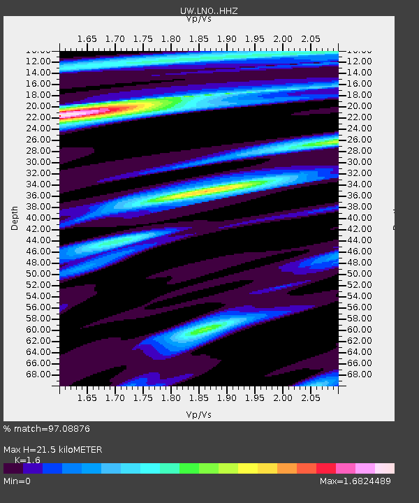
| Estimated Moho Depth: |
21.5 km |
| Estimated Crust Vp/Vs: |
1.60 |
| Assumed Crust Vp: |
6.571 km/s |
| Estimated Crust Vs: |
4.107 km/s |
| Estimated Crust Poisson's Ratio: |
0.18 |
|
| Radial Match: |
97.08876 % |
| Radial Bump: |
400 |
| Transverse Match: |
83.3372 % |
| Transverse Bump: |
400 |
| SOD ConfigId: |
13570011 |
| Insert Time: |
2019-05-02 14:08:23.455 +0000 |
| GWidth: |
2.5 |
| Max Bumps: |
400 |
| Tol: |
0.001 |
|

Signal To Noise
| Channel | StoN | STA | LTA |
| UW:LNO: :HHZ:20190222T10:26:45.449978Z | 23.332054 | 3.3540568E-6 | 1.4375318E-7 |
| UW:LNO: :HHN:20190222T10:26:45.449978Z | 4.484618 | 5.813394E-7 | 1.2962964E-7 |
| UW:LNO: :HHE:20190222T10:26:45.449978Z | 4.3567977 | 9.1641914E-7 | 2.1034236E-7 |
| Arrivals |
| Ps | 2.1 SECOND |
| PpPs | 8.1 SECOND |
| PsPs/PpSs | 10 SECOND |


