You are here: Home > Network List > YX16 - Raton Basin UNM Broadband Network Stations List
> Station UNM3 SW Corner of NM Stations > Earthquake Result Viewer
UNM3 SW Corner of NM Stations - Earthquake Result Viewer
| Earthquake location: |
Peru-Ecuador Border Region |
| Earthquake latitude/longitude: |
-2.2/-77.0 |
| Earthquake time(UTC): |
2019/02/22 (053) 10:17:22 GMT |
| Earthquake Depth: |
132 km |
| Earthquake Magnitude: |
7.5 mww |
| Earthquake Catalog/Contributor: |
NEIC PDE/us |
|
| Network: |
YX Raton Basin UNM Broadband Network |
| Station: |
UNM3 SW Corner of NM Stations |
| Lat/Lon: |
36.84 N/105.04 W |
| Elevation: |
2575 m |
|
| Distance: |
46.8 deg |
| Az: |
328.856 deg |
| Baz: |
139.892 deg |
| Ray Param: |
0.06995249 |
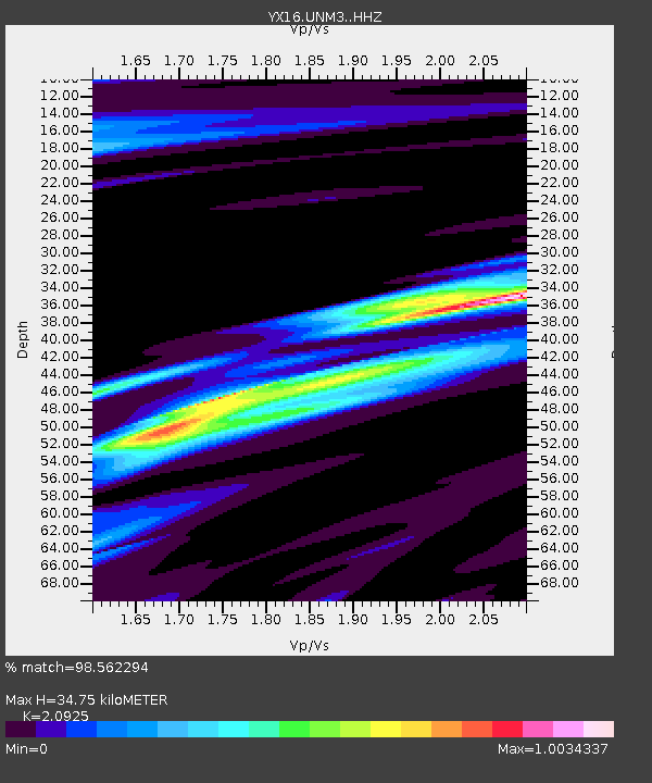
| Estimated Moho Depth: |
34.75 km |
| Estimated Crust Vp/Vs: |
2.09 |
| Assumed Crust Vp: |
6.316 km/s |
| Estimated Crust Vs: |
3.018 km/s |
| Estimated Crust Poisson's Ratio: |
0.35 |
|
| Radial Match: |
98.562294 % |
| Radial Bump: |
278 |
| Transverse Match: |
90.906166 % |
| Transverse Bump: |
400 |
| SOD ConfigId: |
13570011 |
| Insert Time: |
2019-05-02 14:09:24.499 +0000 |
| GWidth: |
2.5 |
| Max Bumps: |
400 |
| Tol: |
0.001 |
|

Signal To Noise
| Channel | StoN | STA | LTA |
| YX:UNM3: :HHZ:20190222T10:25:07.950009Z | 62.05934 | 7.970615E-6 | 1.2843539E-7 |
| YX:UNM3: :HHN:20190222T10:25:07.950009Z | 8.223133 | 1.8631681E-6 | 2.2657643E-7 |
| YX:UNM3: :HHE:20190222T10:25:07.950009Z | 6.341304 | 1.6453646E-6 | 2.5946787E-7 |
| Arrivals |
| Ps | 6.3 SECOND |
| PpPs | 16 SECOND |
| PsPs/PpSs | 23 SECOND |


