You are here: Home > Network List > TA - USArray Transportable Network (new EarthScope stations) Stations List
> Station K19A Absolon Red Butte, Lander, WY, USA > Earthquake Result Viewer
K19A Absolon Red Butte, Lander, WY, USA - Earthquake Result Viewer
| Earthquake location: |
Windward Islands |
| Earthquake latitude/longitude: |
15.0/-61.3 |
| Earthquake time(UTC): |
2007/11/29 (333) 19:00:19 GMT |
| Earthquake Depth: |
148 km |
| Earthquake Magnitude: |
6.9 MB, 7.4 MW, 7.4 MW |
| Earthquake Catalog/Contributor: |
WHDF/NEIC |
|
| Network: |
TA USArray Transportable Network (new EarthScope stations) |
| Station: |
K19A Absolon Red Butte, Lander, WY, USA |
| Lat/Lon: |
42.82 N/108.85 W |
| Elevation: |
1878 m |
|
| Distance: |
49.2 deg |
| Az: |
314.146 deg |
| Baz: |
109.498 deg |
| Ray Param: |
0.068348505 |
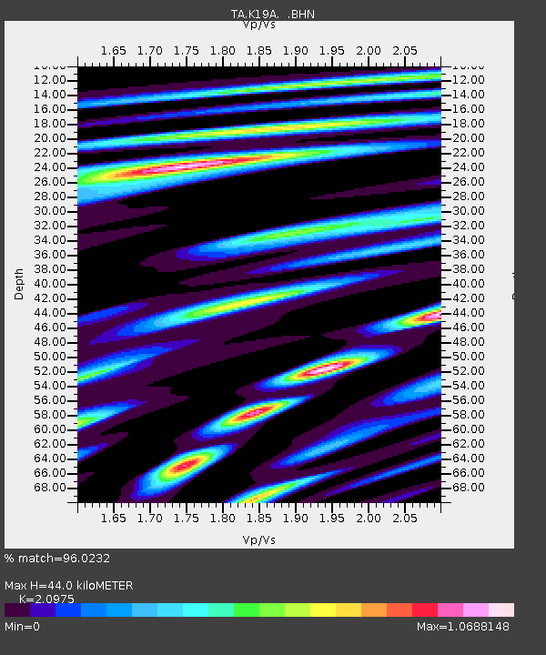
| Estimated Moho Depth: |
44.0 km |
| Estimated Crust Vp/Vs: |
2.10 |
| Assumed Crust Vp: |
6.161 km/s |
| Estimated Crust Vs: |
2.937 km/s |
| Estimated Crust Poisson's Ratio: |
0.35 |
|
| Radial Match: |
96.0232 % |
| Radial Bump: |
370 |
| Transverse Match: |
88.13426 % |
| Transverse Bump: |
400 |
| SOD ConfigId: |
2564 |
| Insert Time: |
2010-03-06 20:20:21.538 +0000 |
| GWidth: |
2.5 |
| Max Bumps: |
400 |
| Tol: |
0.001 |
|
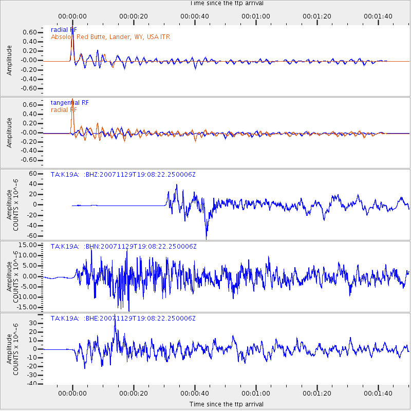
Signal To Noise
| Channel | StoN | STA | LTA |
| TA:K19A: :BHN:20071129T19:08:22.250006Z | 12.300861 | 2.8208244E-6 | 2.2931927E-7 |
| TA:K19A: :BHE:20071129T19:08:22.250006Z | 47.614468 | 7.811671E-6 | 1.6406088E-7 |
| TA:K19A: :BHZ:20071129T19:08:22.250006Z | 57.18039 | 1.43739235E-5 | 2.5137857E-7 |
| Arrivals |
| Ps | 8.2 SECOND |
| PpPs | 21 SECOND |
| PsPs/PpSs | 29 SECOND |


