You are here: Home > Network List > TA - USArray Transportable Network (new EarthScope stations) Stations List
> Station K19A Absolon Red Butte, Lander, WY, USA > Earthquake Result Viewer
K19A Absolon Red Butte, Lander, WY, USA - Earthquake Result Viewer
| Earthquake location: |
Norwegian Sea |
| Earthquake latitude/longitude: |
72.2/0.9 |
| Earthquake time(UTC): |
2009/08/20 (232) 06:35:04 GMT |
| Earthquake Depth: |
6.0 km |
| Earthquake Magnitude: |
5.9 MB, 5.7 MS, 6.0 MW, 6.0 MW |
| Earthquake Catalog/Contributor: |
WHDF/NEIC |
|
| Network: |
TA USArray Transportable Network (new EarthScope stations) |
| Station: |
K19A Absolon Red Butte, Lander, WY, USA |
| Lat/Lon: |
42.82 N/108.85 W |
| Elevation: |
1878 m |
|
| Distance: |
55.4 deg |
| Az: |
302.754 deg |
| Baz: |
20.584 deg |
| Ray Param: |
0.06482801 |
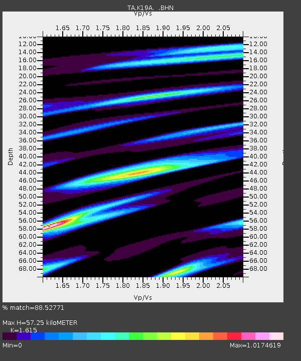
| Estimated Moho Depth: |
57.25 km |
| Estimated Crust Vp/Vs: |
1.62 |
| Assumed Crust Vp: |
6.161 km/s |
| Estimated Crust Vs: |
3.815 km/s |
| Estimated Crust Poisson's Ratio: |
0.19 |
|
| Radial Match: |
88.52771 % |
| Radial Bump: |
400 |
| Transverse Match: |
78.16253 % |
| Transverse Bump: |
400 |
| SOD ConfigId: |
2622 |
| Insert Time: |
2010-03-06 20:20:34.742 +0000 |
| GWidth: |
2.5 |
| Max Bumps: |
400 |
| Tol: |
0.001 |
|

Signal To Noise
| Channel | StoN | STA | LTA |
| TA:K19A: :BHN:20090820T06:44:08.32502Z | 11.3916855 | 5.979028E-7 | 5.24859E-8 |
| TA:K19A: :BHE:20090820T06:44:08.32502Z | 5.1081676 | 2.503908E-7 | 4.9017736E-8 |
| TA:K19A: :BHZ:20090820T06:44:08.32502Z | 3.443919 | 1.7192126E-7 | 4.9920242E-8 |
| Arrivals |
| Ps | 6.0 SECOND |
| PpPs | 23 SECOND |
| PsPs/PpSs | 29 SECOND |


