You are here: Home > Network List > GB - Great Britain Seismograph Network Stations List
> Station IOMK KIRK MICHAEL, ISLE OF MAN > Earthquake Result Viewer
IOMK KIRK MICHAEL, ISLE OF MAN - Earthquake Result Viewer
| Earthquake location: |
Near Coast Of Ecuador |
| Earthquake latitude/longitude: |
-2.3/-79.7 |
| Earthquake time(UTC): |
2019/02/22 (053) 10:40:41 GMT |
| Earthquake Depth: |
82 km |
| Earthquake Magnitude: |
5.5 mb |
| Earthquake Catalog/Contributor: |
NEIC PDE/us |
|
| Network: |
GB Great Britain Seismograph Network |
| Station: |
IOMK KIRK MICHAEL, ISLE OF MAN |
| Lat/Lon: |
54.26 N/4.57 W |
| Elevation: |
188 m |
|
| Distance: |
83.2 deg |
| Az: |
34.828 deg |
| Baz: |
256.577 deg |
| Ray Param: |
0.046162307 |
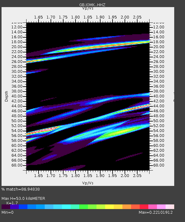
| Estimated Moho Depth: |
53.0 km |
| Estimated Crust Vp/Vs: |
1.70 |
| Assumed Crust Vp: |
6.276 km/s |
| Estimated Crust Vs: |
3.692 km/s |
| Estimated Crust Poisson's Ratio: |
0.24 |
|
| Radial Match: |
86.94838 % |
| Radial Bump: |
400 |
| Transverse Match: |
40.785263 % |
| Transverse Bump: |
400 |
| SOD ConfigId: |
13570011 |
| Insert Time: |
2019-05-02 14:13:11.673 +0000 |
| GWidth: |
2.5 |
| Max Bumps: |
400 |
| Tol: |
0.001 |
|

Signal To Noise
| Channel | StoN | STA | LTA |
| GB:IOMK: :HHZ:20190222T10:52:27.629978Z | 1.7909192 | 1.6851513E-5 | 9.409421E-6 |
| GB:IOMK: :HHN:20190222T10:52:27.629978Z | 0.621259 | 6.883822E-6 | 1.1080439E-5 |
| GB:IOMK: :HHE:20190222T10:52:27.629978Z | 2.7098312 | 1.1971816E-5 | 4.4179196E-6 |
| Arrivals |
| Ps | 6.1 SECOND |
| PpPs | 22 SECOND |
| PsPs/PpSs | 28 SECOND |


