You are here: Home > Network List > TA - USArray Transportable Network (new EarthScope stations) Stations List
> Station C16K Lisburne Hills, AK, USA > Earthquake Result Viewer
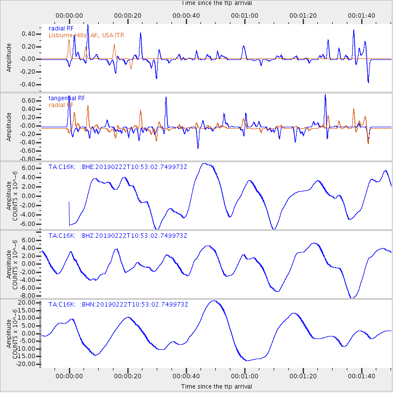
C16K Lisburne Hills, AK, USA - Earthquake Result Viewer
*The percent match for this event was below the threshold and hence no stack was calculated.
| Earthquake location: |
Near Coast Of Ecuador |
| Earthquake latitude/longitude: |
-2.3/-79.7 |
| Earthquake time(UTC): |
2019/02/22 (053) 10:40:41 GMT |
| Earthquake Depth: |
82 km |
| Earthquake Magnitude: |
5.5 mb |
| Earthquake Catalog/Contributor: |
NEIC PDE/us |
|
| Network: |
TA USArray Transportable Network (new EarthScope stations) |
| Station: |
C16K Lisburne Hills, AK, USA |
| Lat/Lon: |
68.27 N/165.34 W |
| Elevation: |
102 m |
|
| Distance: |
90.5 deg |
| Az: |
338.209 deg |
| Baz: |
94.923 deg |
| Ray Param: |
$rayparam |
*The percent match for this event was below the threshold and hence was not used in the summary stack. |
|
| Radial Match: |
60.80861 % |
| Radial Bump: |
267 |
| Transverse Match: |
30.223112 % |
| Transverse Bump: |
167 |
| SOD ConfigId: |
13570011 |
| Insert Time: |
2019-05-02 14:16:14.152 +0000 |
| GWidth: |
2.5 |
| Max Bumps: |
400 |
| Tol: |
0.001 |
|
Signal To Noise
| Channel | StoN | STA | LTA |
| TA:C16K: :BHZ:20190222T10:53:02.749973Z | 0.5595441 | 1.8727917E-6 | 3.346996E-6 |
| TA:C16K: :BHN:20190222T10:53:02.749973Z | 6.187388 | 7.2856396E-6 | 1.1774985E-6 |
| TA:C16K: :BHE:20190222T10:53:02.749973Z | 1.8308114 | 5.9135805E-6 | 3.2300327E-6 |
| Arrivals |
| Ps | |
| PpPs | |
| PsPs/PpSs | |


