You are here: Home > Network List > TA - USArray Transportable Network (new EarthScope stations) Stations List
> Station K19A Absolon Red Butte, Lander, WY, USA > Earthquake Result Viewer
K19A Absolon Red Butte, Lander, WY, USA - Earthquake Result Viewer
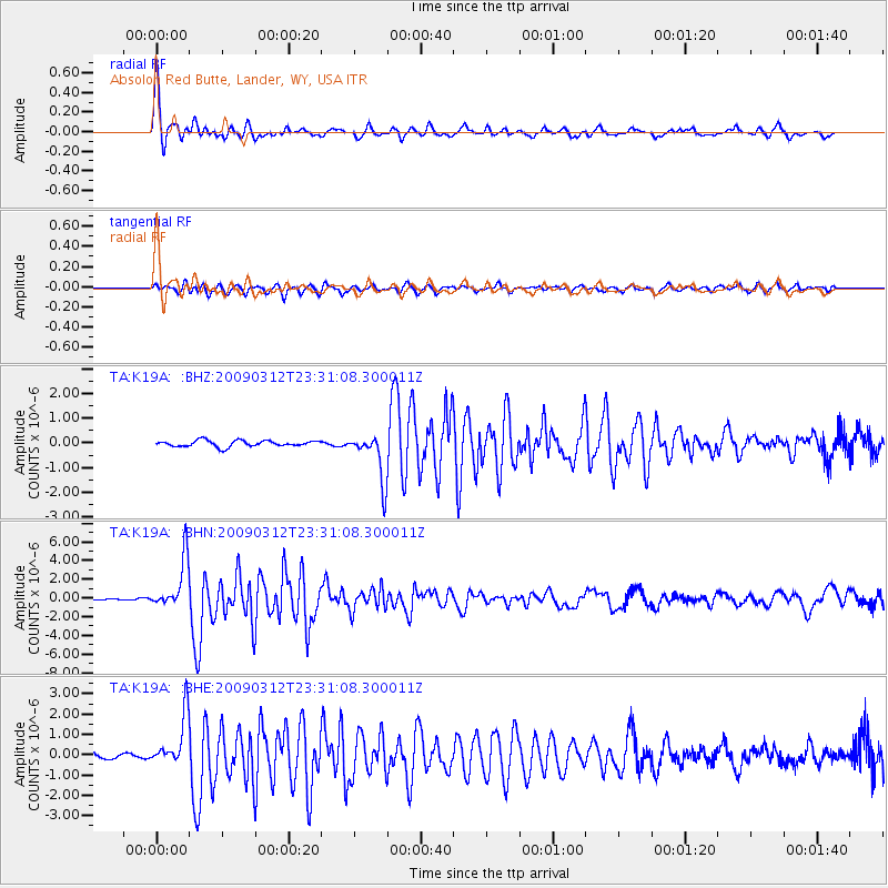
| Earthquake location: |
South Of Panama |
| Earthquake latitude/longitude: |
5.7/-82.8 |
| Earthquake time(UTC): |
2009/03/12 (071) 23:23:34 GMT |
| Earthquake Depth: |
9.0 km |
| Earthquake Magnitude: |
6.1 MB, 5.9 MS, 6.3 MW, 6.2 MW |
| Earthquake Catalog/Contributor: |
WHDF/NEIC |
|
| Network: |
TA USArray Transportable Network (new EarthScope stations) |
| Station: |
K19A Absolon Red Butte, Lander, WY, USA |
| Lat/Lon: |
42.82 N/108.85 W |
| Elevation: |
1878 m |
|
| Distance: |
43.6 deg |
| Az: |
332.027 deg |
| Baz: |
140.62 deg |
| Ray Param: |
0.07245497 |
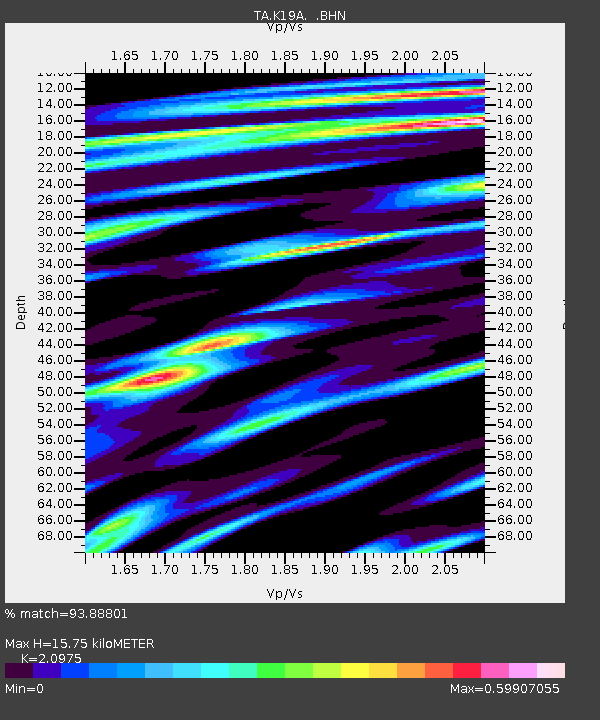
| Estimated Moho Depth: |
15.75 km |
| Estimated Crust Vp/Vs: |
2.10 |
| Assumed Crust Vp: |
6.161 km/s |
| Estimated Crust Vs: |
2.937 km/s |
| Estimated Crust Poisson's Ratio: |
0.35 |
|
| Radial Match: |
93.88801 % |
| Radial Bump: |
379 |
| Transverse Match: |
89.21452 % |
| Transverse Bump: |
400 |
| SOD ConfigId: |
2658 |
| Insert Time: |
2010-03-06 20:20:57.814 +0000 |
| GWidth: |
2.5 |
| Max Bumps: |
400 |
| Tol: |
0.001 |
|
Signal To Noise
| Channel | StoN | STA | LTA |
| TA:K19A: :BHN:20090312T23:31:08.300011Z | 35.322758 | 2.651399E-6 | 7.506206E-8 |
| TA:K19A: :BHE:20090312T23:31:08.300011Z | 8.053401 | 1.2371007E-6 | 1.536122E-7 |
| TA:K19A: :BHZ:20090312T23:31:08.300011Z | 7.573777 | 9.541056E-7 | 1.2597488E-7 |
| Arrivals |
| Ps | 3.0 SECOND |
| PpPs | 7.5 SECOND |
| PsPs/PpSs | 10 SECOND |


