You are here: Home > Network List > TA - USArray Transportable Network (new EarthScope stations) Stations List
> Station O17K Koliganek, Bristol Bay, AK, USA > Earthquake Result Viewer
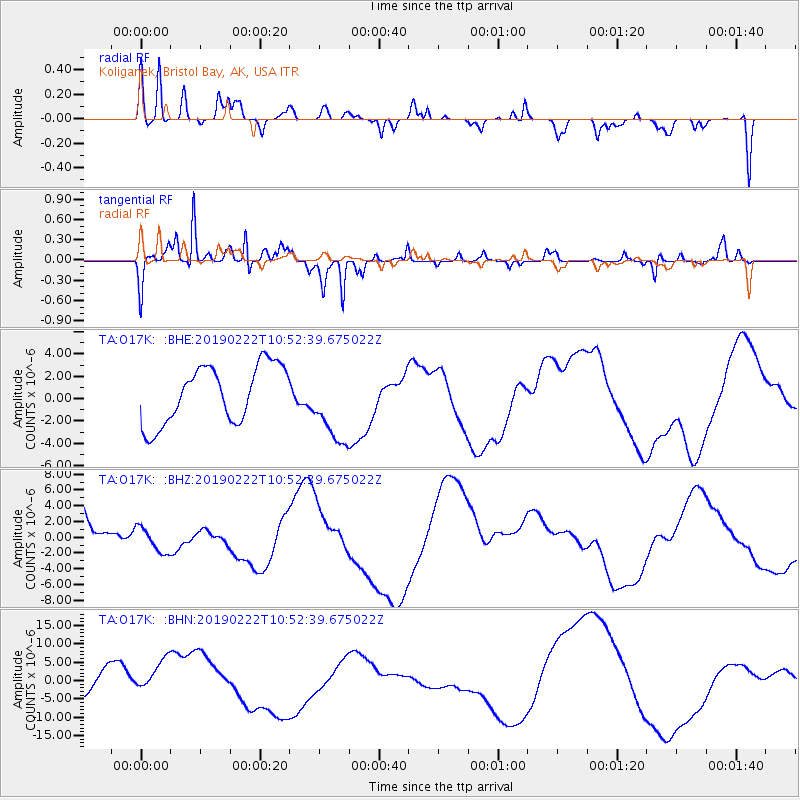
O17K Koliganek, Bristol Bay, AK, USA - Earthquake Result Viewer
*The percent match for this event was below the threshold and hence no stack was calculated.
| Earthquake location: |
Near Coast Of Ecuador |
| Earthquake latitude/longitude: |
-2.3/-79.7 |
| Earthquake time(UTC): |
2019/02/22 (053) 10:40:41 GMT |
| Earthquake Depth: |
82 km |
| Earthquake Magnitude: |
5.5 mb |
| Earthquake Catalog/Contributor: |
NEIC PDE/us |
|
| Network: |
TA USArray Transportable Network (new EarthScope stations) |
| Station: |
O17K Koliganek, Bristol Bay, AK, USA |
| Lat/Lon: |
59.77 N/157.09 W |
| Elevation: |
156 m |
|
| Distance: |
85.6 deg |
| Az: |
330.322 deg |
| Baz: |
102.084 deg |
| Ray Param: |
$rayparam |
*The percent match for this event was below the threshold and hence was not used in the summary stack. |
|
| Radial Match: |
54.26661 % |
| Radial Bump: |
349 |
| Transverse Match: |
80.78658 % |
| Transverse Bump: |
257 |
| SOD ConfigId: |
13570011 |
| Insert Time: |
2019-05-02 14:17:07.105 +0000 |
| GWidth: |
2.5 |
| Max Bumps: |
400 |
| Tol: |
0.001 |
|
Signal To Noise
| Channel | StoN | STA | LTA |
| TA:O17K: :BHZ:20190222T10:52:39.675022Z | 0.4785242 | 1.5492285E-6 | 3.2375133E-6 |
| TA:O17K: :BHN:20190222T10:52:39.675022Z | 2.3289258 | 5.7110938E-6 | 2.4522435E-6 |
| TA:O17K: :BHE:20190222T10:52:39.675022Z | 1.3526123 | 3.474725E-6 | 2.5688996E-6 |
| Arrivals |
| Ps | |
| PpPs | |
| PsPs/PpSs | |


