You are here: Home > Network List > TA - USArray Transportable Network (new EarthScope stations) Stations List
> Station K19A Absolon Red Butte, Lander, WY, USA > Earthquake Result Viewer
K19A Absolon Red Butte, Lander, WY, USA - Earthquake Result Viewer
| Earthquake location: |
Sea Of Okhotsk |
| Earthquake latitude/longitude: |
53.9/152.9 |
| Earthquake time(UTC): |
2008/07/05 (187) 02:12:04 GMT |
| Earthquake Depth: |
633 km |
| Earthquake Magnitude: |
6.8 MB, 7.7 MW, 7.7 MW |
| Earthquake Catalog/Contributor: |
WHDF/NEIC |
|
| Network: |
TA USArray Transportable Network (new EarthScope stations) |
| Station: |
K19A Absolon Red Butte, Lander, WY, USA |
| Lat/Lon: |
42.82 N/108.85 W |
| Elevation: |
1878 m |
|
| Distance: |
61.1 deg |
| Az: |
56.263 deg |
| Baz: |
317.995 deg |
| Ray Param: |
0.058553252 |
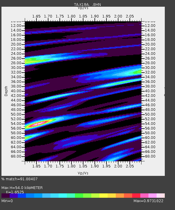
| Estimated Moho Depth: |
54.0 km |
| Estimated Crust Vp/Vs: |
1.65 |
| Assumed Crust Vp: |
6.161 km/s |
| Estimated Crust Vs: |
3.728 km/s |
| Estimated Crust Poisson's Ratio: |
0.21 |
|
| Radial Match: |
91.88407 % |
| Radial Bump: |
400 |
| Transverse Match: |
82.63885 % |
| Transverse Bump: |
400 |
| SOD ConfigId: |
2504 |
| Insert Time: |
2010-03-06 20:21:42.044 +0000 |
| GWidth: |
2.5 |
| Max Bumps: |
400 |
| Tol: |
0.001 |
|
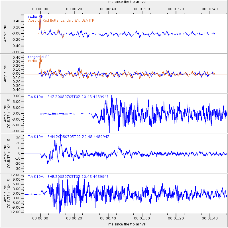
Signal To Noise
| Channel | StoN | STA | LTA |
| TA:K19A: :BHN:20080705T02:20:48.448994Z | 64.5298 | 6.9053717E-6 | 1.07010585E-7 |
| TA:K19A: :BHE:20080705T02:20:48.448994Z | 26.039806 | 2.0429459E-6 | 7.8454725E-8 |
| TA:K19A: :BHZ:20080705T02:20:48.448994Z | 21.343075 | 1.7183827E-6 | 8.051243E-8 |
| Arrivals |
| Ps | 6.0 SECOND |
| PpPs | 22 SECOND |
| PsPs/PpSs | 28 SECOND |


