You are here: Home > Network List > TA - USArray Transportable Network (new EarthScope stations) Stations List
> Station D23K Nanushuk River, AK USA > Earthquake Result Viewer
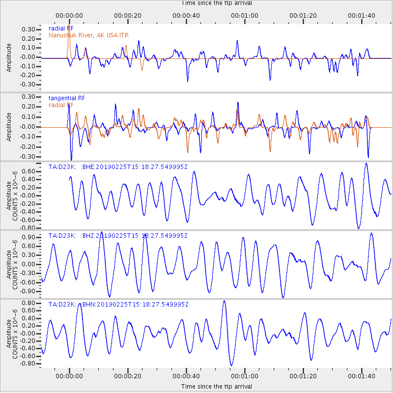
D23K Nanushuk River, AK USA - Earthquake Result Viewer
*The percent match for this event was below the threshold and hence no stack was calculated.
| Earthquake location: |
Central Mid-Atlantic Ridge |
| Earthquake latitude/longitude: |
4.3/-32.6 |
| Earthquake time(UTC): |
2019/02/25 (056) 15:05:33 GMT |
| Earthquake Depth: |
10 km |
| Earthquake Magnitude: |
5.5 Mww |
| Earthquake Catalog/Contributor: |
NEIC PDE/us |
|
| Network: |
TA USArray Transportable Network (new EarthScope stations) |
| Station: |
D23K Nanushuk River, AK USA |
| Lat/Lon: |
68.97 N/150.68 W |
| Elevation: |
406 m |
|
| Distance: |
95.7 deg |
| Az: |
341.326 deg |
| Baz: |
62.18 deg |
| Ray Param: |
$rayparam |
*The percent match for this event was below the threshold and hence was not used in the summary stack. |
|
| Radial Match: |
52.933487 % |
| Radial Bump: |
400 |
| Transverse Match: |
60.974705 % |
| Transverse Bump: |
400 |
| SOD ConfigId: |
13570011 |
| Insert Time: |
2019-05-02 14:33:24.388 +0000 |
| GWidth: |
2.5 |
| Max Bumps: |
400 |
| Tol: |
0.001 |
|
Signal To Noise
| Channel | StoN | STA | LTA |
| TA:D23K: :BHZ:20190225T15:18:27.549995Z | 0.8245266 | 3.1225758E-7 | 3.7871135E-7 |
| TA:D23K: :BHN:20190225T15:18:27.549995Z | 2.3282747 | 5.277497E-7 | 2.2666985E-7 |
| TA:D23K: :BHE:20190225T15:18:27.549995Z | 1.2172846 | 3.2577654E-7 | 2.6762564E-7 |
| Arrivals |
| Ps | |
| PpPs | |
| PsPs/PpSs | |


