You are here: Home > Network List > TA - USArray Transportable Network (new EarthScope stations) Stations List
> Station 121A Cookes Peak, Deming, NM, USA > Earthquake Result Viewer
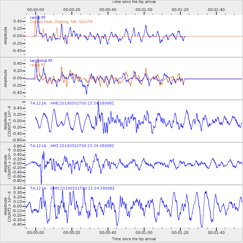
121A Cookes Peak, Deming, NM, USA - Earthquake Result Viewer
*The percent match for this event was below the threshold and hence no stack was calculated.
| Earthquake location: |
Santiago Del Estero Prov., Arg. |
| Earthquake latitude/longitude: |
-28.2/-63.2 |
| Earthquake time(UTC): |
2019/03/01 (060) 00:13:28 GMT |
| Earthquake Depth: |
574 km |
| Earthquake Magnitude: |
5.5 Mww |
| Earthquake Catalog/Contributor: |
NEIC PDE/us |
|
| Network: |
TA USArray Transportable Network (new EarthScope stations) |
| Station: |
121A Cookes Peak, Deming, NM, USA |
| Lat/Lon: |
32.53 N/107.79 W |
| Elevation: |
1652 m |
|
| Distance: |
73.8 deg |
| Az: |
321.885 deg |
| Baz: |
139.851 deg |
| Ray Param: |
$rayparam |
*The percent match for this event was below the threshold and hence was not used in the summary stack. |
|
| Radial Match: |
51.44666 % |
| Radial Bump: |
366 |
| Transverse Match: |
51.78539 % |
| Transverse Bump: |
400 |
| SOD ConfigId: |
13570011 |
| Insert Time: |
2019-05-02 14:41:15.585 +0000 |
| GWidth: |
2.5 |
| Max Bumps: |
400 |
| Tol: |
0.001 |
|
Signal To Noise
| Channel | StoN | STA | LTA |
| TA:121A: :HHZ:20190301T00:23:34.38998Z | 1.8730985 | 2.9928896E-7 | 1.5978283E-7 |
| TA:121A: :HHN:20190301T00:23:34.38998Z | 1.0748274 | 1.5183944E-7 | 1.4126869E-7 |
| TA:121A: :HHE:20190301T00:23:34.38998Z | 1.1656739 | 2.0537453E-7 | 1.7618524E-7 |
| Arrivals |
| Ps | |
| PpPs | |
| PsPs/PpSs | |


