You are here: Home > Network List > C1 - Red Sismologica Nacional Stations List
> Station MG03 ISLA DAWSON > Earthquake Result Viewer
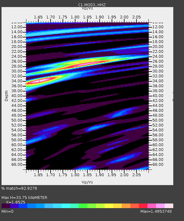
MG03 ISLA DAWSON - Earthquake Result Viewer
| Earthquake location: |
Central Peru |
| Earthquake latitude/longitude: |
-14.7/-70.1 |
| Earthquake time(UTC): |
2019/03/01 (060) 08:50:41 GMT |
| Earthquake Depth: |
257 km |
| Earthquake Magnitude: |
7.0 mww |
| Earthquake Catalog/Contributor: |
NEIC PDE/us |
|
| Network: |
C1 Red Sismologica Nacional |
| Station: |
MG03 ISLA DAWSON |
| Lat/Lon: |
53.85 S/70.46 W |
| Elevation: |
83 m |
|
| Distance: |
39.1 deg |
| Az: |
180.316 deg |
| Baz: |
0.516 deg |
| Ray Param: |
0.074177615 |
| Estimated Moho Depth: |
33.75 km |
| Estimated Crust Vp/Vs: |
1.65 |
| Assumed Crust Vp: |
6.079 km/s |
| Estimated Crust Vs: |
3.679 km/s |
| Estimated Crust Poisson's Ratio: |
0.21 |
|
| Radial Match: |
92.9279 % |
| Radial Bump: |
390 |
| Transverse Match: |
83.46309 % |
| Transverse Bump: |
400 |
| SOD ConfigId: |
13570011 |
| Insert Time: |
2019-05-02 14:47:26.992 +0000 |
| GWidth: |
2.5 |
| Max Bumps: |
400 |
| Tol: |
0.001 |
|

Signal To Noise
| Channel | StoN | STA | LTA |
| C1:MG03: :HHZ:20190301T08:57:13.489991Z | 27.06328 | 1.7160488E-5 | 6.340875E-7 |
| C1:MG03: :HHN:20190301T08:57:13.489991Z | 13.337118 | 8.321868E-6 | 6.2396305E-7 |
| C1:MG03: :HHE:20190301T08:57:13.489991Z | 2.7482936 | 1.894155E-6 | 6.892113E-7 |
| Arrivals |
| Ps | 3.9 SECOND |
| PpPs | 14 SECOND |
| PsPs/PpSs | 18 SECOND |


