You are here: Home > Network List > CI - Caltech Regional Seismic Network Stations List
> Station DGR Domenigoni Reservoir, California, USA > Earthquake Result Viewer
DGR Domenigoni Reservoir, California, USA - Earthquake Result Viewer
| Earthquake location: |
Central Peru |
| Earthquake latitude/longitude: |
-14.7/-70.1 |
| Earthquake time(UTC): |
2019/03/01 (060) 08:50:41 GMT |
| Earthquake Depth: |
257 km |
| Earthquake Magnitude: |
7.0 mww |
| Earthquake Catalog/Contributor: |
NEIC PDE/us |
|
| Network: |
CI Caltech Regional Seismic Network |
| Station: |
DGR Domenigoni Reservoir, California, USA |
| Lat/Lon: |
33.65 N/117.01 W |
| Elevation: |
609 m |
|
| Distance: |
65.6 deg |
| Az: |
318.048 deg |
| Baz: |
129.142 deg |
| Ray Param: |
0.057358865 |
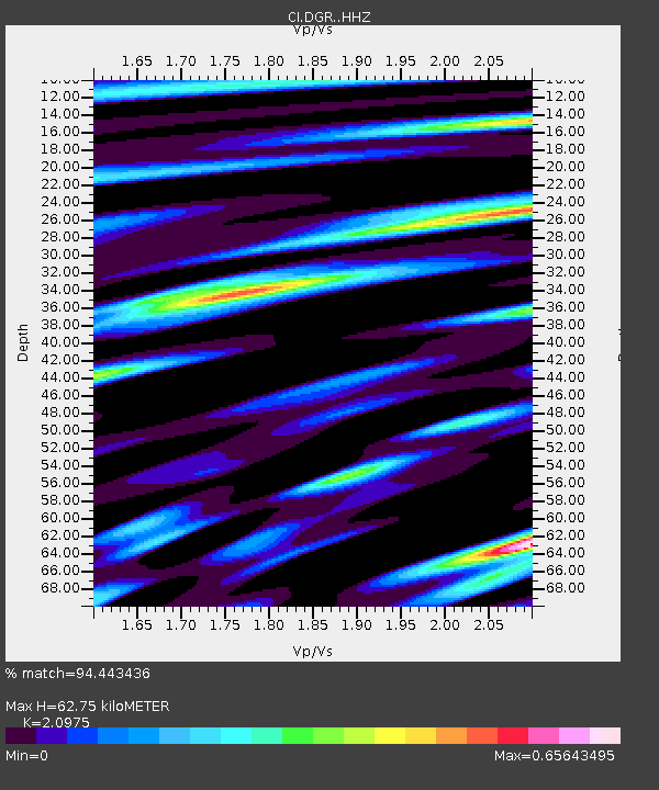
| Estimated Moho Depth: |
62.75 km |
| Estimated Crust Vp/Vs: |
2.10 |
| Assumed Crust Vp: |
6.264 km/s |
| Estimated Crust Vs: |
2.986 km/s |
| Estimated Crust Poisson's Ratio: |
0.35 |
|
| Radial Match: |
94.443436 % |
| Radial Bump: |
400 |
| Transverse Match: |
80.20939 % |
| Transverse Bump: |
400 |
| SOD ConfigId: |
13570011 |
| Insert Time: |
2019-05-02 14:48:16.530 +0000 |
| GWidth: |
2.5 |
| Max Bumps: |
400 |
| Tol: |
0.001 |
|

Signal To Noise
| Channel | StoN | STA | LTA |
| CI:DGR: :HHZ:20190301T09:00:27.378022Z | 9.48395 | 1.8738082E-6 | 1.9757678E-7 |
| CI:DGR: :HHN:20190301T09:00:27.378022Z | 3.5849364 | 5.463199E-7 | 1.5239318E-7 |
| CI:DGR: :HHE:20190301T09:00:27.378022Z | 6.4137516 | 5.631094E-7 | 8.77972E-8 |
| Arrivals |
| Ps | 11 SECOND |
| PpPs | 30 SECOND |
| PsPs/PpSs | 41 SECOND |


