You are here: Home > Network List > CI - Caltech Regional Seismic Network Stations List
> Station SMM Simmler, CA, USA > Earthquake Result Viewer
SMM Simmler, CA, USA - Earthquake Result Viewer
| Earthquake location: |
Central Peru |
| Earthquake latitude/longitude: |
-14.7/-70.1 |
| Earthquake time(UTC): |
2019/03/01 (060) 08:50:41 GMT |
| Earthquake Depth: |
257 km |
| Earthquake Magnitude: |
7.0 mww |
| Earthquake Catalog/Contributor: |
NEIC PDE/us |
|
| Network: |
CI Caltech Regional Seismic Network |
| Station: |
SMM Simmler, CA, USA |
| Lat/Lon: |
35.31 N/120.00 W |
| Elevation: |
599 m |
|
| Distance: |
68.6 deg |
| Az: |
317.804 deg |
| Baz: |
127.364 deg |
| Ray Param: |
0.055446975 |
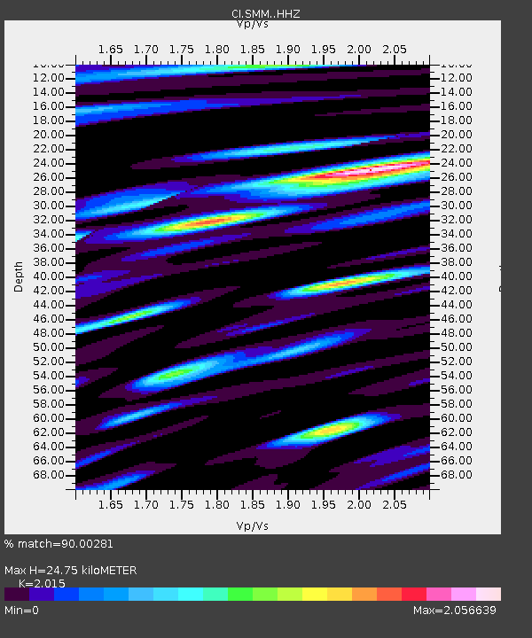
| Estimated Moho Depth: |
24.75 km |
| Estimated Crust Vp/Vs: |
2.02 |
| Assumed Crust Vp: |
6.1 km/s |
| Estimated Crust Vs: |
3.027 km/s |
| Estimated Crust Poisson's Ratio: |
0.34 |
|
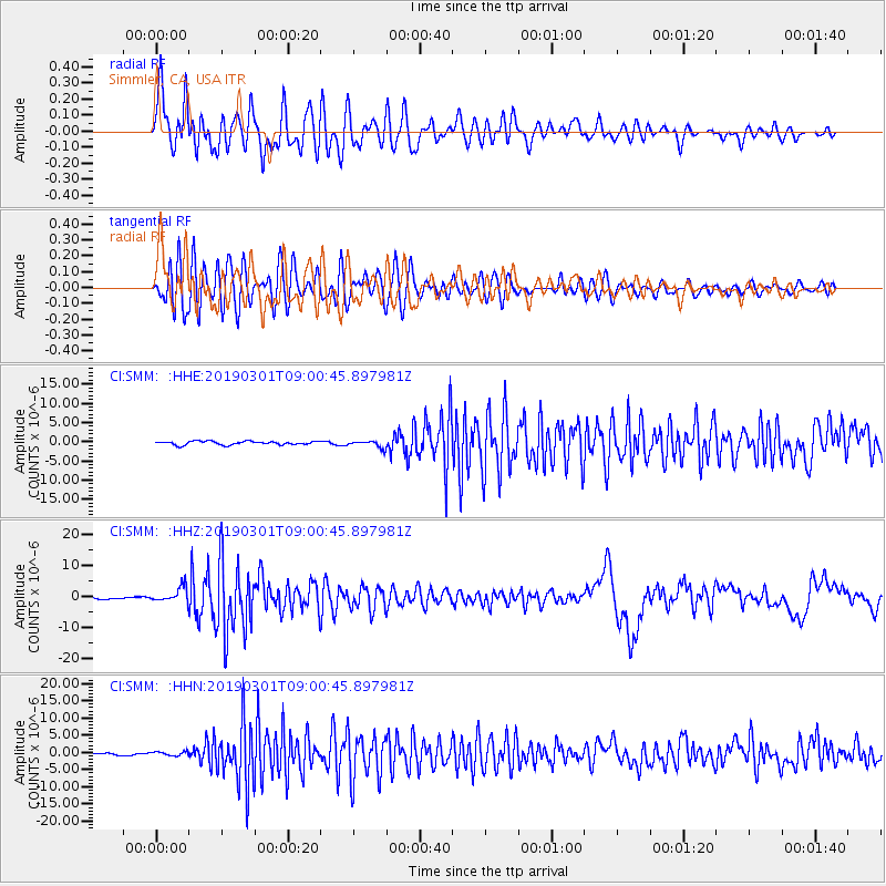
| Radial Match: |
90.00281 % |
| Radial Bump: |
400 |
| Transverse Match: |
89.182686 % |
| Transverse Bump: |
400 |
| SOD ConfigId: |
13570011 |
| Insert Time: |
2019-05-02 14:48:47.112 +0000 |
| GWidth: |
2.5 |
| Max Bumps: |
400 |
| Tol: |
0.001 |
|
Signal To Noise
| Channel | StoN | STA | LTA |
| CI:SMM: :HHZ:20190301T09:00:45.897981Z | 8.393082 | 2.492567E-6 | 2.9697878E-7 |
| CI:SMM: :HHN:20190301T09:00:45.897981Z | 1.6157924 | 5.763287E-7 | 3.566849E-7 |
| CI:SMM: :HHE:20190301T09:00:45.897981Z | 1.8561864 | 8.5448187E-7 | 4.6034268E-7 |
| Arrivals |
| Ps | 4.2 SECOND |
| PpPs | 12 SECOND |
| PsPs/PpSs | 16 SECOND |


