You are here: Home > Network List > US - United States National Seismic Network Stations List
> Station DGMT Dagmar, Montana, USA > Earthquake Result Viewer
DGMT Dagmar, Montana, USA - Earthquake Result Viewer
| Earthquake location: |
Off East Coast Of Honshu, Japan |
| Earthquake latitude/longitude: |
34.5/141.7 |
| Earthquake time(UTC): |
2016/09/23 (267) 00:14:33 GMT |
| Earthquake Depth: |
10 km |
| Earthquake Magnitude: |
6.4 MWP, 6.3 MWW |
| Earthquake Catalog/Contributor: |
NEIC PDE/NEIC COMCAT |
|
| Network: |
US United States National Seismic Network |
| Station: |
DGMT Dagmar, Montana, USA |
| Lat/Lon: |
48.47 N/104.20 W |
| Elevation: |
0.0 m |
|
| Distance: |
78.7 deg |
| Az: |
38.302 deg |
| Baz: |
309.718 deg |
| Ray Param: |
0.04949548 |
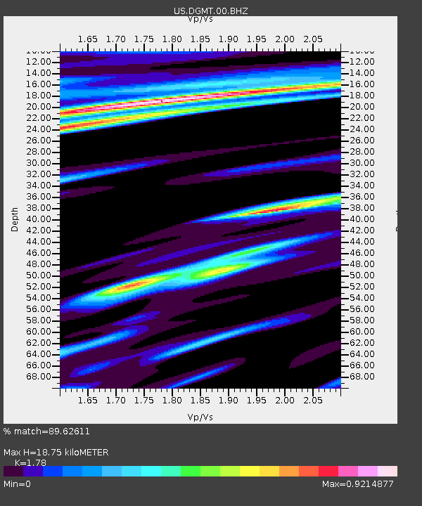
| Estimated Moho Depth: |
18.75 km |
| Estimated Crust Vp/Vs: |
1.78 |
| Assumed Crust Vp: |
6.438 km/s |
| Estimated Crust Vs: |
3.617 km/s |
| Estimated Crust Poisson's Ratio: |
0.27 |
|
| Radial Match: |
89.62611 % |
| Radial Bump: |
400 |
| Transverse Match: |
65.45074 % |
| Transverse Bump: |
373 |
| SOD ConfigId: |
1634031 |
| Insert Time: |
2016-10-07 00:31:53.170 +0000 |
| GWidth: |
2.5 |
| Max Bumps: |
400 |
| Tol: |
0.001 |
|

Signal To Noise
| Channel | StoN | STA | LTA |
| US:DGMT:00:BHZ:20160923T00:26:04.549026Z | 3.4787455 | 5.163053E-7 | 1.484171E-7 |
| US:DGMT:00:BH1:20160923T00:26:04.549026Z | 0.75716037 | 4.5297398E-7 | 5.982537E-7 |
| US:DGMT:00:BH2:20160923T00:26:04.549026Z | 1.3348513 | 4.0826052E-7 | 3.058472E-7 |
| Arrivals |
| Ps | 2.3 SECOND |
| PpPs | 7.9 SECOND |
| PsPs/PpSs | 10 SECOND |


