You are here: Home > Network List > CN - Canadian National Seismograph Network Stations List
> Station GOBB Galiano Island, BC, CA > Earthquake Result Viewer
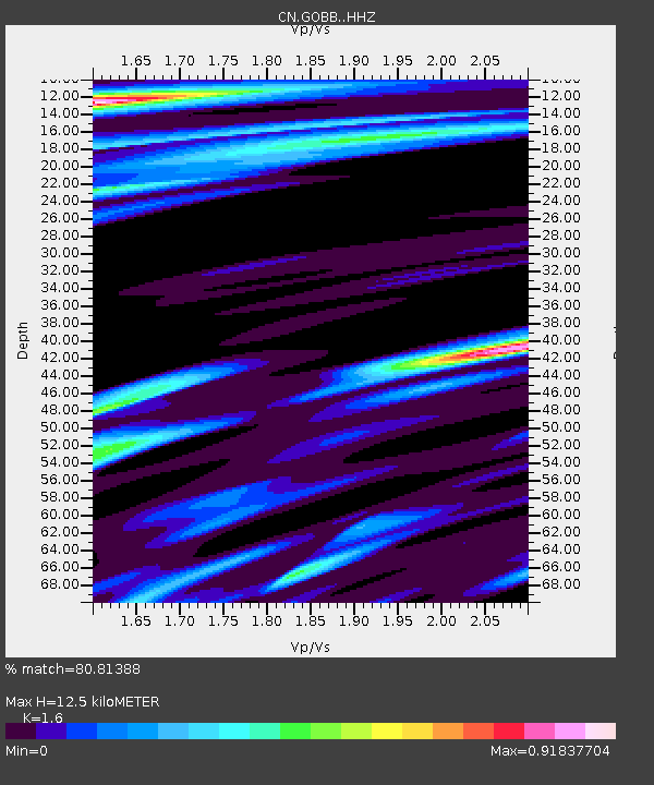
GOBB Galiano Island, BC, CA - Earthquake Result Viewer
| Earthquake location: |
Central Peru |
| Earthquake latitude/longitude: |
-14.7/-70.1 |
| Earthquake time(UTC): |
2019/03/01 (060) 08:50:41 GMT |
| Earthquake Depth: |
257 km |
| Earthquake Magnitude: |
7.0 mww |
| Earthquake Catalog/Contributor: |
NEIC PDE/us |
|
| Network: |
CN Canadian National Seismograph Network |
| Station: |
GOBB Galiano Island, BC, CA |
| Lat/Lon: |
48.95 N/123.51 W |
| Elevation: |
143 m |
|
| Distance: |
79.0 deg |
| Az: |
327.38 deg |
| Baz: |
127.688 deg |
| Ray Param: |
0.048598927 |
| Estimated Moho Depth: |
12.5 km |
| Estimated Crust Vp/Vs: |
1.60 |
| Assumed Crust Vp: |
6.566 km/s |
| Estimated Crust Vs: |
4.104 km/s |
| Estimated Crust Poisson's Ratio: |
0.18 |
|
| Radial Match: |
80.81388 % |
| Radial Bump: |
400 |
| Transverse Match: |
55.32569 % |
| Transverse Bump: |
400 |
| SOD ConfigId: |
13570011 |
| Insert Time: |
2019-05-02 14:49:31.877 +0000 |
| GWidth: |
2.5 |
| Max Bumps: |
400 |
| Tol: |
0.001 |
|

Signal To Noise
| Channel | StoN | STA | LTA |
| CN:GOBB: :HHZ:20190301T09:01:45.860017Z | 9.424133 | 3.0015076E-6 | 3.1849163E-7 |
| CN:GOBB: :HHN:20190301T09:01:45.860017Z | 0.5782795 | 1.8772546E-6 | 3.2462756E-6 |
| CN:GOBB: :HHE:20190301T09:01:45.860017Z | 0.7245781 | 3.0876365E-6 | 4.2612887E-6 |
| Arrivals |
| Ps | 1.2 SECOND |
| PpPs | 4.8 SECOND |
| PsPs/PpSs | 6.0 SECOND |


