You are here: Home > Network List > CN - Canadian National Seismograph Network Stations List
> Station PABB Port Alberni, BC, CA > Earthquake Result Viewer
PABB Port Alberni, BC, CA - Earthquake Result Viewer
| Earthquake location: |
Central Peru |
| Earthquake latitude/longitude: |
-14.7/-70.1 |
| Earthquake time(UTC): |
2019/03/01 (060) 08:50:41 GMT |
| Earthquake Depth: |
257 km |
| Earthquake Magnitude: |
7.0 mww |
| Earthquake Catalog/Contributor: |
NEIC PDE/us |
|
| Network: |
CN Canadian National Seismograph Network |
| Station: |
PABB Port Alberni, BC, CA |
| Lat/Lon: |
49.22 N/124.81 W |
| Elevation: |
3.0 m |
|
| Distance: |
79.8 deg |
| Az: |
327.073 deg |
| Baz: |
126.652 deg |
| Ray Param: |
0.048033103 |
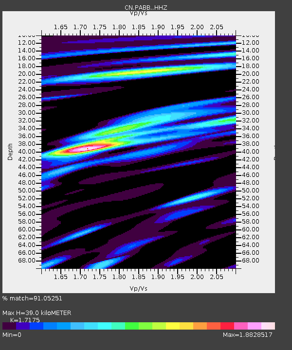
| Estimated Moho Depth: |
39.0 km |
| Estimated Crust Vp/Vs: |
1.72 |
| Assumed Crust Vp: |
6.391 km/s |
| Estimated Crust Vs: |
3.721 km/s |
| Estimated Crust Poisson's Ratio: |
0.24 |
|
| Radial Match: |
91.05251 % |
| Radial Bump: |
400 |
| Transverse Match: |
79.89924 % |
| Transverse Bump: |
400 |
| SOD ConfigId: |
13570011 |
| Insert Time: |
2019-05-02 14:50:05.276 +0000 |
| GWidth: |
2.5 |
| Max Bumps: |
400 |
| Tol: |
0.001 |
|

Signal To Noise
| Channel | StoN | STA | LTA |
| CN:PABB: :HHZ:20190301T09:01:50.379976Z | 7.3160195 | 1.7967957E-6 | 2.4559745E-7 |
| CN:PABB: :HHN:20190301T09:01:50.379976Z | 1.1507608 | 4.057136E-7 | 3.5256122E-7 |
| CN:PABB: :HHE:20190301T09:01:50.379976Z | 4.2439065 | 8.6891225E-7 | 2.0474349E-7 |
| Arrivals |
| Ps | 4.5 SECOND |
| PpPs | 16 SECOND |
| PsPs/PpSs | 21 SECOND |


