You are here: Home > Network List > US - United States National Seismic Network Stations List
> Station SCIA State Center, Iowa, USA > Earthquake Result Viewer
SCIA State Center, Iowa, USA - Earthquake Result Viewer
| Earthquake location: |
Off East Coast Of Honshu, Japan |
| Earthquake latitude/longitude: |
34.5/141.7 |
| Earthquake time(UTC): |
2016/09/23 (267) 00:14:33 GMT |
| Earthquake Depth: |
10 km |
| Earthquake Magnitude: |
6.4 MWP, 6.3 MWW |
| Earthquake Catalog/Contributor: |
NEIC PDE/NEIC COMCAT |
|
| Network: |
US United States National Seismic Network |
| Station: |
SCIA State Center, Iowa, USA |
| Lat/Lon: |
41.91 N/93.22 W |
| Elevation: |
312 m |
|
| Distance: |
88.8 deg |
| Az: |
37.685 deg |
| Baz: |
317.438 deg |
| Ray Param: |
0.042328868 |
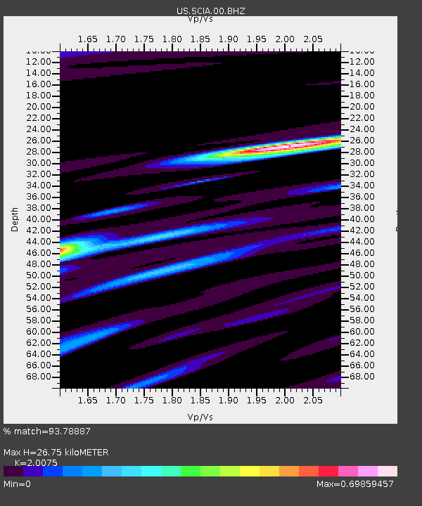
| Estimated Moho Depth: |
26.75 km |
| Estimated Crust Vp/Vs: |
2.01 |
| Assumed Crust Vp: |
6.498 km/s |
| Estimated Crust Vs: |
3.237 km/s |
| Estimated Crust Poisson's Ratio: |
0.33 |
|
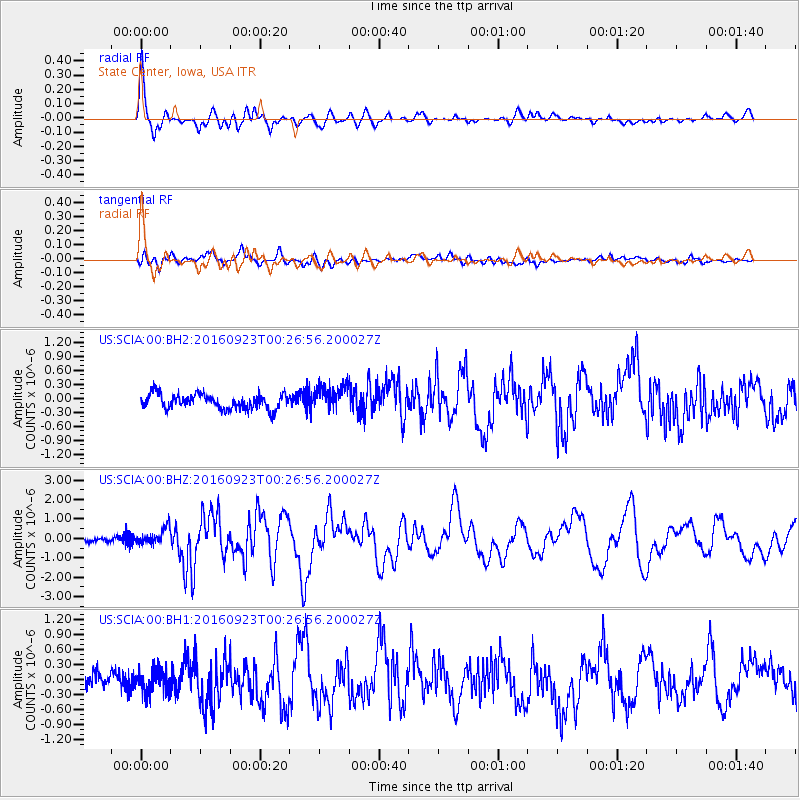
| Radial Match: |
93.78887 % |
| Radial Bump: |
400 |
| Transverse Match: |
63.781254 % |
| Transverse Bump: |
400 |
| SOD ConfigId: |
1634031 |
| Insert Time: |
2016-10-07 00:33:57.970 +0000 |
| GWidth: |
2.5 |
| Max Bumps: |
400 |
| Tol: |
0.001 |
|
Signal To Noise
| Channel | StoN | STA | LTA |
| US:SCIA:00:BHZ:20160923T00:26:56.200027Z | 3.2592785 | 4.1612995E-7 | 1.2767548E-7 |
| US:SCIA:00:BH1:20160923T00:26:56.200027Z | 1.3497277 | 2.3555938E-7 | 1.7452363E-7 |
| US:SCIA:00:BH2:20160923T00:26:56.200027Z | 1.7361419 | 2.801148E-7 | 1.6134327E-7 |
| Arrivals |
| Ps | 4.2 SECOND |
| PpPs | 12 SECOND |
| PsPs/PpSs | 16 SECOND |


