You are here: Home > Network List > N4 - Central and EAstern US Network Stations List
> Station L42A Oliver, Polo, IL, USA > Earthquake Result Viewer
L42A Oliver, Polo, IL, USA - Earthquake Result Viewer
| Earthquake location: |
Central Peru |
| Earthquake latitude/longitude: |
-14.7/-70.1 |
| Earthquake time(UTC): |
2019/03/01 (060) 08:50:41 GMT |
| Earthquake Depth: |
257 km |
| Earthquake Magnitude: |
7.0 mww |
| Earthquake Catalog/Contributor: |
NEIC PDE/us |
|
| Network: |
N4 Central and EAstern US Network |
| Station: |
L42A Oliver, Polo, IL, USA |
| Lat/Lon: |
42.00 N/89.67 W |
| Elevation: |
257 m |
|
| Distance: |
59.2 deg |
| Az: |
343.132 deg |
| Baz: |
157.866 deg |
| Ray Param: |
0.06146628 |
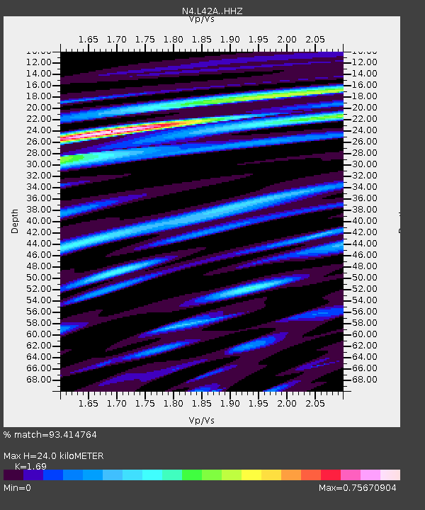
| Estimated Moho Depth: |
24.0 km |
| Estimated Crust Vp/Vs: |
1.69 |
| Assumed Crust Vp: |
6.571 km/s |
| Estimated Crust Vs: |
3.888 km/s |
| Estimated Crust Poisson's Ratio: |
0.23 |
|
| Radial Match: |
93.414764 % |
| Radial Bump: |
327 |
| Transverse Match: |
66.40577 % |
| Transverse Bump: |
400 |
| SOD ConfigId: |
13570011 |
| Insert Time: |
2019-05-02 14:53:25.634 +0000 |
| GWidth: |
2.5 |
| Max Bumps: |
400 |
| Tol: |
0.001 |
|

Signal To Noise
| Channel | StoN | STA | LTA |
| N4:L42A: :HHZ:20190301T08:59:45.30002Z | 28.888758 | 6.7755323E-6 | 2.3453873E-7 |
| N4:L42A: :HHN:20190301T08:59:45.30002Z | 12.784201 | 3.5422486E-6 | 2.7708018E-7 |
| N4:L42A: :HHE:20190301T08:59:45.30002Z | 6.8388505 | 1.3776004E-6 | 2.0143742E-7 |
| Arrivals |
| Ps | 2.7 SECOND |
| PpPs | 9.3 SECOND |
| PsPs/PpSs | 12 SECOND |


