You are here: Home > Network List > TA - USArray Transportable Network (new EarthScope stations) Stations List
> Station W23A Werner Place, Edgewood, NM, USA > Earthquake Result Viewer
W23A Werner Place, Edgewood, NM, USA - Earthquake Result Viewer
| Earthquake location: |
South Of Panama |
| Earthquake latitude/longitude: |
6.7/-82.6 |
| Earthquake time(UTC): |
2009/10/22 (295) 00:51:39 GMT |
| Earthquake Depth: |
18 km |
| Earthquake Magnitude: |
5.5 MB, 5.4 MS, 5.9 MW, 5.9 MW |
| Earthquake Catalog/Contributor: |
WHDF/NEIC |
|
| Network: |
TA USArray Transportable Network (new EarthScope stations) |
| Station: |
W23A Werner Place, Edgewood, NM, USA |
| Lat/Lon: |
35.16 N/106.15 W |
| Elevation: |
2020 m |
|
| Distance: |
35.6 deg |
| Az: |
325.791 deg |
| Baz: |
137.04 deg |
| Ray Param: |
0.07709105 |
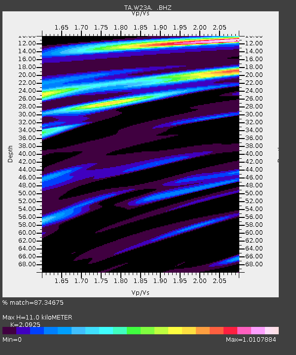
| Estimated Moho Depth: |
11.0 km |
| Estimated Crust Vp/Vs: |
2.09 |
| Assumed Crust Vp: |
6.502 km/s |
| Estimated Crust Vs: |
3.107 km/s |
| Estimated Crust Poisson's Ratio: |
0.35 |
|
| Radial Match: |
87.34675 % |
| Radial Bump: |
400 |
| Transverse Match: |
56.668613 % |
| Transverse Bump: |
400 |
| SOD ConfigId: |
2622 |
| Insert Time: |
2010-03-06 20:24:40.948 +0000 |
| GWidth: |
2.5 |
| Max Bumps: |
400 |
| Tol: |
0.001 |
|
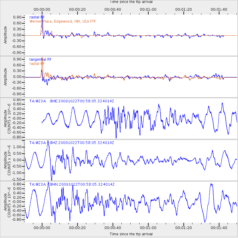
Signal To Noise
| Channel | StoN | STA | LTA |
| TA:W23A: :BHZ:20091022T00:58:05.324014Z | 2.5606616 | 7.520058E-7 | 2.9367638E-7 |
| TA:W23A: :BHN:20091022T00:58:05.324014Z | 1.5899594 | 5.051609E-7 | 3.1771938E-7 |
| TA:W23A: :BHE:20091022T00:58:05.324014Z | 1.259432 | 2.8536815E-7 | 2.265848E-7 |
| Arrivals |
| Ps | 2.0 SECOND |
| PpPs | 4.9 SECOND |
| PsPs/PpSs | 6.9 SECOND |


