You are here: Home > Network List > TA - USArray Transportable Network (new EarthScope stations) Stations List
> Station W23A Werner Place, Edgewood, NM, USA > Earthquake Result Viewer
W23A Werner Place, Edgewood, NM, USA - Earthquake Result Viewer
| Earthquake location: |
South Of Tonga Islands |
| Earthquake latitude/longitude: |
-24.1/-175.2 |
| Earthquake time(UTC): |
2009/11/02 (306) 10:47:13 GMT |
| Earthquake Depth: |
9.0 km |
| Earthquake Magnitude: |
6.1 MB, 6.1 MS, 6.2 MW, 6.1 MW |
| Earthquake Catalog/Contributor: |
WHDF/NEIC |
|
| Network: |
TA USArray Transportable Network (new EarthScope stations) |
| Station: |
W23A Werner Place, Edgewood, NM, USA |
| Lat/Lon: |
35.16 N/106.15 W |
| Elevation: |
2020 m |
|
| Distance: |
88.0 deg |
| Az: |
49.953 deg |
| Baz: |
238.613 deg |
| Ray Param: |
0.042920016 |
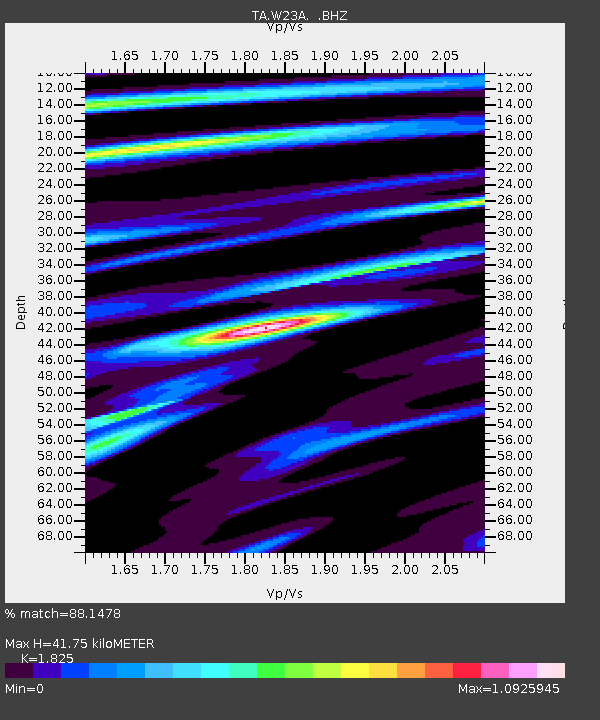
| Estimated Moho Depth: |
41.75 km |
| Estimated Crust Vp/Vs: |
1.83 |
| Assumed Crust Vp: |
6.502 km/s |
| Estimated Crust Vs: |
3.562 km/s |
| Estimated Crust Poisson's Ratio: |
0.29 |
|
| Radial Match: |
88.1478 % |
| Radial Bump: |
353 |
| Transverse Match: |
76.80927 % |
| Transverse Bump: |
400 |
| SOD ConfigId: |
2622 |
| Insert Time: |
2010-03-06 20:24:42.997 +0000 |
| GWidth: |
2.5 |
| Max Bumps: |
400 |
| Tol: |
0.001 |
|
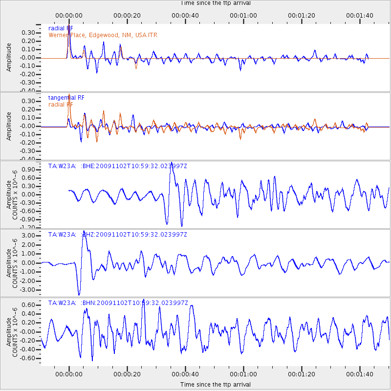
Signal To Noise
| Channel | StoN | STA | LTA |
| TA:W23A: :BHZ:20091102T10:59:32.023997Z | 9.447639 | 1.5648906E-6 | 1.6563827E-7 |
| TA:W23A: :BHN:20091102T10:59:32.023997Z | 0.9239271 | 2.1019389E-7 | 2.2750051E-7 |
| TA:W23A: :BHE:20091102T10:59:32.023997Z | 3.044352 | 4.605898E-7 | 1.5129322E-7 |
| Arrivals |
| Ps | 5.4 SECOND |
| PpPs | 18 SECOND |
| PsPs/PpSs | 23 SECOND |


