You are here: Home > Network List > TA - USArray Transportable Network (new EarthScope stations) Stations List
> Station W23A Werner Place, Edgewood, NM, USA > Earthquake Result Viewer
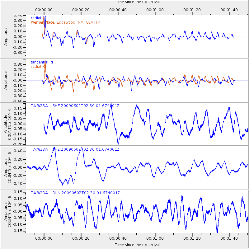
W23A Werner Place, Edgewood, NM, USA - Earthquake Result Viewer
| Earthquake location: |
Vanuatu Islands |
| Earthquake latitude/longitude: |
-17.8/167.9 |
| Earthquake time(UTC): |
2009/06/02 (153) 02:17:03 GMT |
| Earthquake Depth: |
15 km |
| Earthquake Magnitude: |
5.7 MB, 6.2 MS, 6.3 MW, 6.3 MW |
| Earthquake Catalog/Contributor: |
WHDF/NEIC |
|
| Network: |
TA USArray Transportable Network (new EarthScope stations) |
| Station: |
W23A Werner Place, Edgewood, NM, USA |
| Lat/Lon: |
35.16 N/106.15 W |
| Elevation: |
2020 m |
|
| Distance: |
96.8 deg |
| Az: |
55.387 deg |
| Baz: |
253.175 deg |
| Ray Param: |
0.040411074 |
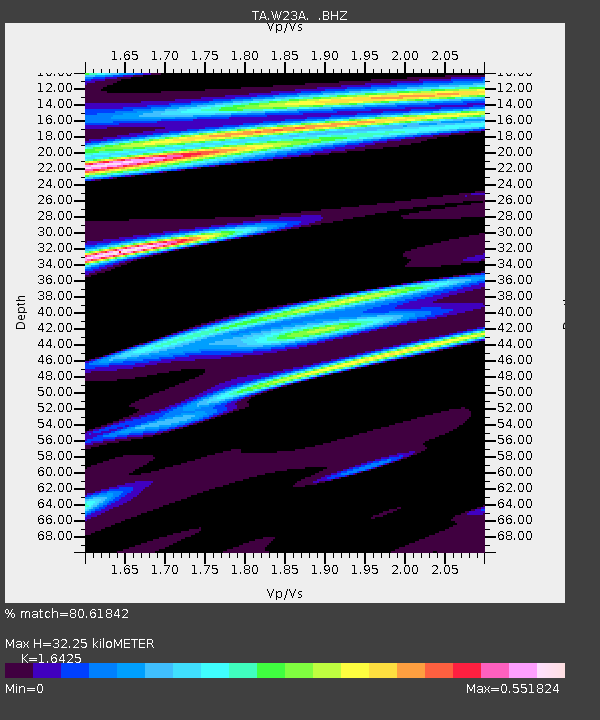
| Estimated Moho Depth: |
32.25 km |
| Estimated Crust Vp/Vs: |
1.64 |
| Assumed Crust Vp: |
6.502 km/s |
| Estimated Crust Vs: |
3.958 km/s |
| Estimated Crust Poisson's Ratio: |
0.21 |
|
| Radial Match: |
80.61842 % |
| Radial Bump: |
400 |
| Transverse Match: |
48.226826 % |
| Transverse Bump: |
400 |
| SOD ConfigId: |
2648 |
| Insert Time: |
2010-03-06 20:24:46.364 +0000 |
| GWidth: |
2.5 |
| Max Bumps: |
400 |
| Tol: |
0.001 |
|
Signal To Noise
| Channel | StoN | STA | LTA |
| TA:W23A: :BHZ:20090602T02:30:01.674001Z | 2.6479301 | 1.688515E-7 | 6.376735E-8 |
| TA:W23A: :BHN:20090602T02:30:01.674001Z | 0.8133388 | 3.688998E-8 | 4.5356224E-8 |
| TA:W23A: :BHE:20090602T02:30:01.674001Z | 1.1868559 | 5.0281123E-8 | 4.2364977E-8 |
| Arrivals |
| Ps | 3.3 SECOND |
| PpPs | 13 SECOND |
| PsPs/PpSs | 16 SECOND |


