You are here: Home > Network List > TA - USArray Transportable Network (new EarthScope stations) Stations List
> Station W23A Werner Place, Edgewood, NM, USA > Earthquake Result Viewer
W23A Werner Place, Edgewood, NM, USA - Earthquake Result Viewer
| Earthquake location: |
Galapagos Islands Region |
| Earthquake latitude/longitude: |
2.4/-95.1 |
| Earthquake time(UTC): |
2009/03/15 (074) 03:14:31 GMT |
| Earthquake Depth: |
10 km |
| Earthquake Magnitude: |
5.5 MS, 5.4 MB, 5.8 MW, 5.8 MW |
| Earthquake Catalog/Contributor: |
WHDF/NEIC |
|
| Network: |
TA USArray Transportable Network (new EarthScope stations) |
| Station: |
W23A Werner Place, Edgewood, NM, USA |
| Lat/Lon: |
35.16 N/106.15 W |
| Elevation: |
2020 m |
|
| Distance: |
34.1 deg |
| Az: |
343.786 deg |
| Baz: |
160.094 deg |
| Ray Param: |
0.07788355 |
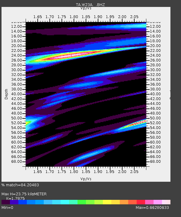
| Estimated Moho Depth: |
23.75 km |
| Estimated Crust Vp/Vs: |
1.79 |
| Assumed Crust Vp: |
6.502 km/s |
| Estimated Crust Vs: |
3.637 km/s |
| Estimated Crust Poisson's Ratio: |
0.27 |
|
| Radial Match: |
84.20483 % |
| Radial Bump: |
308 |
| Transverse Match: |
63.572002 % |
| Transverse Bump: |
400 |
| SOD ConfigId: |
2658 |
| Insert Time: |
2010-03-06 20:24:57.827 +0000 |
| GWidth: |
2.5 |
| Max Bumps: |
400 |
| Tol: |
0.001 |
|
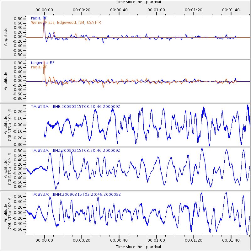
Signal To Noise
| Channel | StoN | STA | LTA |
| TA:W23A: :BHZ:20090315T03:20:46.200009Z | 2.569249 | 3.4706002E-7 | 1.3508229E-7 |
| TA:W23A: :BHN:20090315T03:20:46.200009Z | 3.1164558 | 3.0983213E-7 | 9.94181E-8 |
| TA:W23A: :BHE:20090315T03:20:46.200009Z | 1.1486032 | 9.445781E-8 | 8.2237115E-8 |
| Arrivals |
| Ps | 3.1 SECOND |
| PpPs | 9.4 SECOND |
| PsPs/PpSs | 13 SECOND |


