You are here: Home > Network List > NN - Western Great Basin/Eastern Sierra Nevada Stations List
> Station SHP Sheep Range, Nevada w84gm > Earthquake Result Viewer
SHP Sheep Range, Nevada w84gm - Earthquake Result Viewer
| Earthquake location: |
Central Peru |
| Earthquake latitude/longitude: |
-14.7/-70.1 |
| Earthquake time(UTC): |
2019/03/01 (060) 08:50:41 GMT |
| Earthquake Depth: |
257 km |
| Earthquake Magnitude: |
7.0 mww |
| Earthquake Catalog/Contributor: |
NEIC PDE/us |
|
| Network: |
NN Western Great Basin/Eastern Sierra Nevada |
| Station: |
SHP Sheep Range, Nevada w84gm |
| Lat/Lon: |
36.50 N/115.16 W |
| Elevation: |
1632 m |
|
| Distance: |
66.3 deg |
| Az: |
321.501 deg |
| Baz: |
131.609 deg |
| Ray Param: |
0.056915548 |
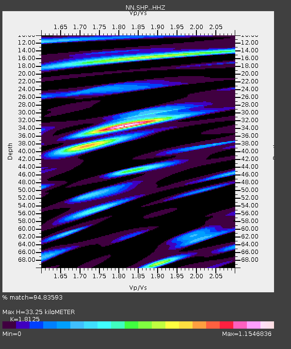
| Estimated Moho Depth: |
33.25 km |
| Estimated Crust Vp/Vs: |
1.81 |
| Assumed Crust Vp: |
6.276 km/s |
| Estimated Crust Vs: |
3.463 km/s |
| Estimated Crust Poisson's Ratio: |
0.28 |
|
| Radial Match: |
94.83593 % |
| Radial Bump: |
400 |
| Transverse Match: |
73.55236 % |
| Transverse Bump: |
400 |
| SOD ConfigId: |
13570011 |
| Insert Time: |
2019-05-02 14:54:59.707 +0000 |
| GWidth: |
2.5 |
| Max Bumps: |
400 |
| Tol: |
0.001 |
|

Signal To Noise
| Channel | StoN | STA | LTA |
| NN:SHP: :HHZ:20190301T09:00:31.740022Z | 12.084992 | 1.0285287E-6 | 8.510793E-8 |
| NN:SHP: :HHN:20190301T09:00:31.740022Z | 4.9081564 | 3.438538E-7 | 7.005763E-8 |
| NN:SHP: :HHE:20190301T09:00:31.740022Z | 5.2648263 | 3.202596E-7 | 6.083004E-8 |
| Arrivals |
| Ps | 4.5 SECOND |
| PpPs | 14 SECOND |
| PsPs/PpSs | 19 SECOND |


